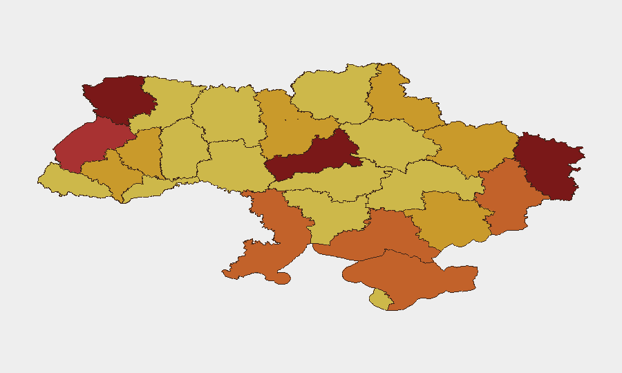
Situation Summary
Ukraine remains engaged in active large-scale warfare with sustained Russian bombardment and Ukrainian long-range strike operations. Over the past 24–48 hours, Russia has launched over 96 air-delivered weapons (ballistic missiles and drones) across multiple regions, while Ukrainian forces have conducted coordinated strikes on Russian military and energy infrastructure in occupied Crimea. The composite threat score places Ukraine at #4 globally, with Cherkasy Oblast and Kyiv presenting the highest sub-national risk levels, driven by proximity to Russian positions, air-defense saturation, and critical infrastructure vulnerability.
Key Developments
- Occupied Crimea, night of July 8–9, 2026: Ukrainian forces executed a large coordinated drone and missile strike campaign targeting approximately 45 Russian military and infrastructure sites, including the Saky Thermal Power Plant, three oil depots, two vehicle maintenance facilities, a Zhitel electronic warfare station, and communications towers. Risk of follow-on strikes and secondary explosions remains elevated.
- Nationwide airspace, night of July 8–9, 2026: Russian forces launched 2 Iskander-M ballistic missiles from occupied Crimea and 94 attack/decoy drones (Shahed, Gerbera, Italmas, Parodiya variants) from staging areas in Bryansk, Oryol, Rostov Oblast, and occupied Donetsk City. Ukrainian MoD identifies ballistic missiles as the greatest current threat to civilians and critical infrastructure.
- Sumy Oblast, ongoing July 8–9, 2026: Ukraine's defense ministry reported that in 2026 alone, Russian forces have conducted over 12,000 missile, glide-bomb, and drone strikes on Sumy Oblast, damaging more than 2,600 residential, educational, medical, and energy facilities, with 122 civilian deaths and over 1,200 injured. Cross-border bombardment patterns remain sustained and intensive.
- Front-line positions, July 9, 2026: No confirmed territorial advances were recorded by either side on July 9, indicating attritional combat dominated by air and artillery strikes rather than mobile warfare or sudden shifts in occupation.
- Northern and eastern approach corridors, July 8–9, 2026: Continued Russian use of border regions (Bryansk, Oryol, Millerovo) and occupied territories as staging grounds for long-range strikes underscores persistent capability for renewed large-scale cross-border attacks and elevated air-defense activity.
Highest-Risk Areas
Cherkasy Oblast (risk 100) and Kyiv (98.4) dominate the sub-national ranking, reflecting their proximity to active Russian positions, exposure to long-range strikes, and strategic importance as military and civilian population centers. Volyn, Luhansk, and Lviv oblasts follow, driven by ongoing bombardment, frontier proximity, and infrastructure vulnerability. The sustained intensity of air strikes nationwide—particularly the 96-weapon overnight attack—elevates risk across all regions; however, northern and eastern oblasts face compounded exposure from cross-border artillery and drone staging operations based in Russia and occupied territories.
How GeoBit Would Assist
Corporate security teams monitoring personnel and assets in Ukraine should deploy Conflict & Military battle mapping and force-structure tracking to monitor active strike patterns and front-line stability, combined with AOI (area-of-interest) monitoring and early-warning alerting on high-risk oblasts (especially Cherkasy, Kyiv, Sumy) to receive real-time notification of new strike activity or corridor closures. Routing & network analysis capabilities enable security teams to calculate and update safe travel corridors and evacuation routes as air-defense saturation and missile launches fluctuate. OSINT fusion and corroboration across conflict feeds, Telegram, and Ukrainian MoD statements provide rapid confirmation of strike locations and infrastructure damage, informing duty-of-care decisions.
7-Day Outlook
Russian air-strike frequency and Ukrainian long-range operations are expected to continue at current or elevated intensity. Personnel movement in and out of Ukraine, particularly through northern and eastern approaches, will remain disrupted by air-defense activity and potential corridor closures. Critical infrastructure damage—especially energy and transport—will sustain logistical challenges for at least the next week absent a significant shift in military tempo.
Highest-Risk Areas — Ranked
| # | State / Region | Risk |
|---|---|---|
| 1 | Cherkasy Oblast | 100 |
| 2 | Kyiv | 98.4 |
| 3 | Volyn Oblast | 80.6 |
| 4 | Luhansk Oblast | 80 |
| 5 | Lviv Oblast | 79.4 |
| 6 | Donetsk Oblast | 75.9 |
| 7 | Kherson Oblast | 73.5 |
| 8 | Autonomous Republic of Crimea | 73.3 |
| 9 | Odesa Oblast | 73 |
| 10 | Ternopil Oblast | 72.9 |
| 11 | Zaporizhia Oblast | 72.1 |
| 12 | Kharkiv Oblast | 71.4 |
Sources
Previous Daily Briefs
A new Ukraine brief is written every day — each with its own risk map and downloadable CSV. Here's the last week; use the calendar to go further back.
📅 Browse every day by calendar →
Highlighted days have a brief. Tap a day for that day's map & analysis, or “csv” for that day's dataset ($5).
Atlas — our AI intelligence desk — emails them this snapshot personally. Nothing else, no list.