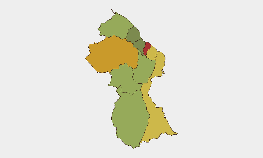
Situation Summary
Guyana remains at low global threat rank (#125, composite score 14) but faces persistent localized violence concentrated in coastal regions. The past week saw two discrete security incidents—a vehicle shooting and infrastructure work—with no mass-casualty events or political instability. Underlying vulnerability to interpersonal and gang-related violence, particularly in Demerara-Mahaica and Cuyuni-Mazaruni regions, persists; however, no escalation or organized campaign was detected in the 6–12 October window.
Key Developments
- Plaisance, East Coast Demerara — 7 October 2026: Police investigated a shooting at a businessman's vehicle on Victoria Road. A suspected projectile was recovered and apparent gunshot damage was confirmed; no injuries reported. Incident suggests continued opportunistic firearms use in commercial areas of the capital region.
- Demerara River, 8 October 2026: Guyana Power and Light reported near-completion of LS6 submarine transmission cable relocation to facilitate Gas-to-Energy infrastructure. Relocation had caused power disruptions; fewer outages expected post-completion. Operational note: critical infrastructure work ongoing; temporary service volatility anticipated.
- Background context (late September): Two consecutive fatal choppings (23-year-old fisherman and labourer, same area, within 24 hours on 28–29 September) and a fatal chopping of a six-year-old boy (1 October) underscore elevated violent-crime activity in coastal regions. An abduction of two Surinamese nationals (charged 1 October) and road-accident fatality in Puruni Trail interior (29 September) reflect distributed rather than concentrated crisis.
Highest-Risk Areas
Demerara-Mahaica (risk 78) and Cuyuni-Mazaruni (risk 72) drive national risk, reflecting high interpersonal violence, gang activity, and trafficking corridors. East Berbice-Corentyne (62) and Mahaica-Berbice (65) also rank elevated, indicating a coastal concentration of criminal activity and organized violence. Upper Demerara-Berbice (58) and interior regions (Potaro-Siparuni, 48) present secondary risks linked to resource-extraction conflict, border permeability, and limited state presence. The capital–coastal corridor remains the primary zone of concern for corporate operations.
How GeoBit Would Assist
Area-of-Interest monitoring with persistent alerting on Demerara-Mahaica, East Coast Demerara, and the Vigilance–Buxton corridor would provide early warning of escalating violence or protest activity before duty-of-care thresholds are crossed. OSINT fusion and multi-language search across local news, police releases, and community channels would enable near-real-time event detection and verification, reducing reliance on delayed official statements. GIS and spatial analysis of violent incidents, infrastructure vulnerability, and alternative routing would support security team contingency planning and personnel movement in high-risk coastal zones. Routing and network analysis would identify safer commercial and residential corridors, particularly around Georgetown and Plaisance, where vehicular and personal security incidents cluster.
7-Day Outlook
No organized escalation or political trigger is evident; risk trajectory remains stable but elevated in localized zones. Interpersonal and gang-driven violence is likely to persist at current baseline through mid-October absent catalyst events (election periods, resource disputes, major trafficking incidents). Security teams should assume continued operational disruption from both crime and infrastructure work; sustained monitoring of Demerara-Mahaica and coastal commercial routes is warranted.
Highest-Risk Areas — Ranked
| # | State / Region | Risk |
|---|---|---|
| 1 | Demerara-Mahaica | 78 |
| 2 | Cuyuni-Mazaruni | 72 |
| 3 | Mahaica-Berbice | 65 |
| 4 | East Berbice-Corentyne | 62 |
| 5 | Upper Demerara-Berbice | 58 |
| 6 | Potaro-Siparuni | 48 |
| 7 | Barima-Waini | 45 |
| 8 | Upper Takutu-Upper Essequibo | 42 |
| 9 | Pomeroon-Supenaam | 38 |
| 10 | Essequibo Islands | 35 |
Sources
Previous Weekly Briefs
A new Guyana brief is written every Monday, covering the week — each with its own risk map and downloadable CSV. Use the calendar to go further back.
- October 5, 2026
- September 28, 2026
- September 21, 2026
- September 14, 2026
- September 7, 2026
- September 1, 2026
- August 30, 2026
📅 Browse past briefs by calendar →
Highlighted days have a brief. Tap a day for that day's map & analysis, or “csv” for that day's dataset ($5).
Atlas — our AI intelligence desk — emails them this snapshot personally. Nothing else, no list.