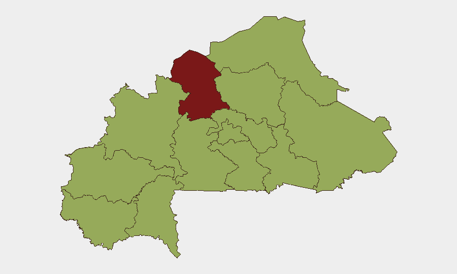
Situation Summary
Burkina Faso remains under severe insurgent pressure, with coordinated jihadist attacks on 30 June across the East and Sahel regions signaling sustained operational capability by JNIM and allied groups. The recent rupture of diplomatic relations with France has introduced political instability alongside military escalation, with government statements linking the timing of attacks to the diplomatic break. Civilian displacement is constrained by military checkpoints in besieged areas, creating a compounding protection and humanitarian crisis. The threat environment is trending upward, with June registering elevated jihadist violence across border zones and northern territories.
Key Developments
- Gayéri, Solhan, Sebba (East/Sahel regions) – 30 June 2026 (confirmed 6 July): Armed forces reported coordinated jihadist assaults followed by counter-operations that killed over 400 militants, with seizure of hundreds of weapons, ammunition stockpiles, and approximately 250 motorcycles. ACLED and military communiqués independently confirm these multi-location attacks as part of a broader insurgent surge.
- Sirba and Liptako border zones (East/Niger border) – 30 June 2026 (reported 6 July): Simultaneous jihadist assaults targeted military positions in cross-border areas, attributed to JNIM and allied factions operating in coordinated fashion across Burkina Faso–Niger frontier regions.
- Civilian evacuation restrictions (North and East regions) – late June–early July 2026, documented 6 July): Army checkpoints are preventing civilians from leaving besieged towns; soldiers are turning back departing residents and, in some instances, using coercion or force, citing counterterrorism rationale. Aid workers and residents report blockades, jihadist checkpoints, and explosive devices creating acute humanitarian and protection risks.
- Humanitarian operations decree (national scope – implemented early July 2026): Government has issued new accreditation and operational restrictions on NGOs, requiring security compliance and state-defined priorities for assistance delivery. This will directly impact NGO access, movement permissions, and delivery of aid to conflict-affected populations.
- France diplomatic rupture (national – announced days before 30 June, discussed 6 July): Burkina Faso severed diplomatic relations with France shortly before the 30 June attacks. Military statements link the attacks to the rupture and accuse France of supporting "terrorist hordes," escalating political tensions and potentially affecting external security cooperation.
- Regional jihadist escalation (Sahel and border areas – June 2026 trend, confirmed 6 July): ACLED's July overview documents a measurable June surge in jihadist violence nationwide, particularly in zones where JNIM and Islamic State-linked groups compete for operational dominance along borders with Niger and Mali.
Highest-Risk Areas
The North region dominates the risk landscape at 84.9, driven by sustained jihadist presence, military counter-operations, and civilian displacement under restricted movement. Upper-Basins, Boucle du Mouhoun, Central-West, Sahel, and East regions cluster at 54.9 risk, reflecting JNIM operational footprint, border volatility (particularly near Niger), and patchy state control. The concentration of risk in northern and eastern territories reflects both geographic proximity to transnational insurgent networks and the military's resource constraints in maintaining contested territory while managing civilian populations.
How GeoBit Would Assist
Security teams should deploy AOI (Area-of-Interest) Monitoring & Early Warning on North, East, and Sahel regions to track real-time conflict activity and checkpoint positioning. Routing & Network Analysis capabilities enable identification of alternative movement corridors and assessment of checkpoint density on primary evacuation routes. Network & Actor Analysis combined with OSINT fusion (X/Telegram, radio SIGINT) will track JNIM and allied faction command communications, attack patterns, and cross-border coordination to anticipate secondary operations.
7-Day Outlook
Jihadist groups will likely sustain pressure on military positions and civilian-held areas to capitalize on the France rupture and potential security-cooperation gaps. Army restrictions on civilian movement and the new humanitarian decree will further constrain civilian access to assistance and egress from besieged zones. Elevated risk across North and East regions should be assumed persistent; border zones warrant heightened monitoring for cross-border incursions and secondary coordinated attacks.
Highest-Risk Areas — Ranked
| # | State / Region | Risk |
|---|---|---|
| 1 | North | 84.9 |
| 2 | Upper-Basins | 54.9 |
| 3 | Boucle du Mouhoun | 54.9 |
| 4 | Central-West | 54.9 |
| 5 | Central-South | 54.9 |
| 6 | Central-East | 54.9 |
| 7 | Waterfalls | 54.9 |
| 8 | Southwest | 54.9 |
| 9 | Sahel | 54.9 |
| 10 | Central-North | 54.9 |
| 11 | East | 54.9 |
| 12 | Centre | 54.9 |
Sources
Previous Daily Briefs
A new Burkina Faso brief is written every day — each with its own risk map and downloadable CSV. Here's the last week; use the calendar to go further back.
📅 Browse every day by calendar →
Highlighted days have a brief. Tap a day for that day's map & analysis, or “csv” for that day's dataset ($5).
Atlas — our AI intelligence desk — emails them this snapshot personally. Nothing else, no list.