Situation Summary
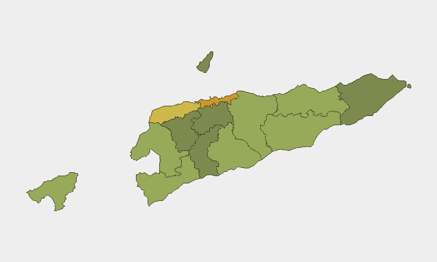
East Timor remains a low-threat environment regionally, ranked #177 globally with a composite threat score of 4 and no tracked security events in the current monitoring window. The country's overall stability profile is stable, though sub-national risk concentration in the capital and western border municipalities—particularly Dili, Liquiçá, and Baucau—reflects localized crime, occasional civil unrest, and historical gang activity. No acute security incidents, protests, armed clashes, or infrastructure disruptions have been documented in open sources for the past 24–48 hours.
Key Developments
Dili (Metiaut, Cristo Rei) – 27 August 2026 – National Police (PNTL) conducted an enforcement operation targeting a suspected online fraud center, resulting in the detention of 16 foreign nationals. Approximately 30 mobile phones, SIM cards, and one vehicle were seized. *Note: This criminal cyber-fraud action falls slightly outside the strict 24–48h window and does not represent a kinetic or unrest incident, but reflects ongoing law-enforcement capacity in the capital.*
Manatuto Municipality – 28–30 August 2026 – Planned commemorative events marking the 27th anniversary of the 1999 Popular Consultation are proceeding without reported disruption, including community clean-up campaigns, religious services, and cultural activities. No unrest or security incidents have been associated with these gatherings.
Dili / National Level – 28 August 2026 – Prime Minister Xanana Gusmão made policy statements regarding maritime border delimitation and resource sovereignty. This represents routine political communication, not an acute incident or trigger for unrest.
*No additional discrete security, unrest, crime, or travel-risk incidents meeting the 24–48h reporting threshold have been identified in available open-source material.*
Highest-Risk Areas
Dili (risk score 72) dominates the country's threat profile, reflecting its concentration of organized crime, gang activity, petty violence, and cyber-crime operations—as evidenced by the 27 August fraud enforcement action. Liquiçá (62) and Baucau (58) follow as secondary risk nodes, with historical gang presence and sporadic civil unrest. Western and border municipalities including Cova Lima, Bobonaro, and Oecussi-Ambeno carry elevated scores reflecting cross-border trafficking, smuggling, and lower state capacity. Eastern and southern regions (Viqueque, Manatuto, Ainaro) and the interior highlands show substantially lower risk and are generally suitable for routine operations.
How GeoBit Would Assist
Security teams operating in or transiting through East Timor should deploy AOI Monitoring & Early Warning on high-risk municipalities (Dili, Liquiçá, Baucau) to capture emerging unrest, gang activity, or protest activity in near-real time. Multi-language OSINT fusion (including Portuguese and Tetum news feeds, social media sentiment analysis, and radio SIGINT) combined with entity extraction and network analysis would enable rapid detection of protest organizers, criminal actors, or political tensions before they escalate. Routing & Network Analysis can provide security personnel with alternative movement corridors bypassing known crime hotspots, particularly in Dili and border zones.
7-Day Outlook
The security environment is expected to remain stable over the next seven days. Commemorative activities in Manatuto should conclude without major disruption by 30 August. Routine enforcement operations (cyber-crime, trafficking interdiction) may continue in Dili and border zones, but no mass-casualty events, political crises, or infrastructure attacks are anticipated. Standard duty-of-care protocols remain appropriate for all locations.
Highest-Risk Areas — Ranked
| # | State / Region | Risk |
|---|---|---|
| 1 | Dili | 72 |
| 2 | Liquiçá | 62 |
| 3 | Baucau | 58 |
| 4 | Cova Lima | 55 |
| 5 | Bobonaro | 53 |
| 6 | Oecussi-Ambeno | 48 |
| 7 | Manufahi | 45 |
| 8 | Viqueque | 42 |
| 9 | Manatuto | 40 |
| 10 | Ainaro | 38 |
| 11 | Ermera | 36 |
| 12 | Aileu | 32 |
Sources
Previous Daily Briefs
A new East Timor brief is written every day — each with its own risk map and downloadable CSV. Here's the last week; use the calendar to go further back.
- August 26, 2026
- August 23, 2026
- August 20, 2026
- August 18, 2026
- August 16, 2026
- August 14, 2026
- August 12, 2026
📅 Browse every day by calendar →
Highlighted days have a brief. Tap a day for that day's map & analysis, or “csv” for that day's dataset ($5).
Atlas — our AI intelligence desk — emails them this snapshot personally. Nothing else, no list.