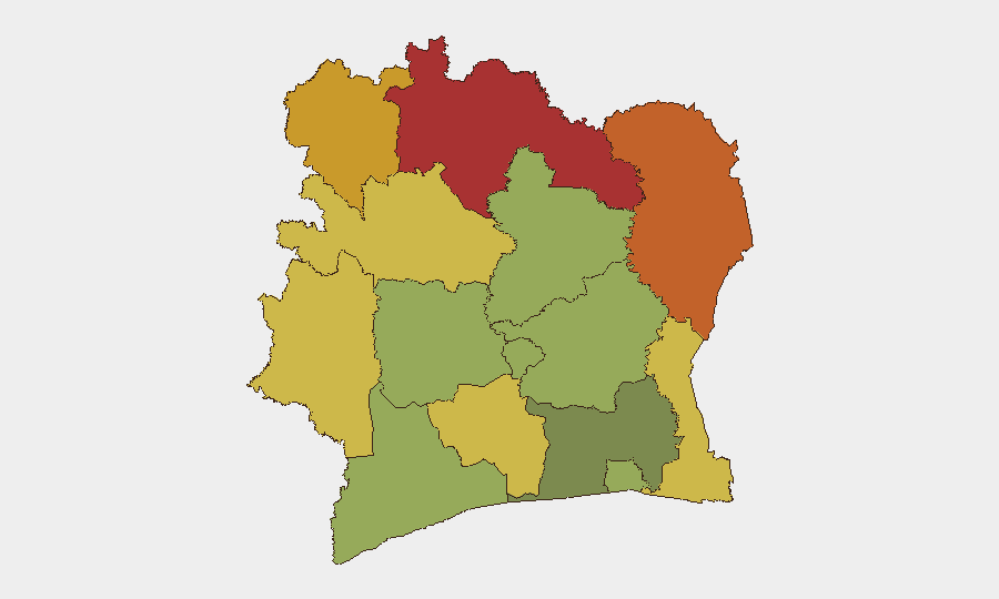
Situation Summary
Ivory Coast remains a stable mid-tier security environment (global rank #70, composite threat score 25) with no tracked discrete security events in the current reporting window. The country's principal risk concentration is in the northern and northeastern districts (Savanes, Zanzan, Denguélé, Comoé), where cross-border exposure, limited state presence, and historical militia activity sustain elevated threat levels. Abidjan and the southern economic zones remain substantially lower-risk, though organized crime and petty violence remain routine management concerns for corporate operations.
Key Developments
- Abidjan, Port/Airport (2026-08-25): Media reports indicate a potential contractual dispute between Menzies Aviation and Abidjan airport authorities following expiration of the ground-handling concession. No operational disruption or passenger impact has been confirmed; status remains unverified and under watch.
- Nationwide (2026-08-25): August 25 declared a public holiday and non-working day across Ivory Coast; administrative scheduling rather than security incident, but relevant for business continuity and staffing planning.
- Standing Travel Advisories (as of 2026-08-25): German and other international travel services continue to list Ivory Coast under partial travel warnings, consistent with longer-standing advisories and not indicative of new deterioration in the last 48 hours.
- No Active Security Events: Zero confirmed incidents of violence, roadblocks, protests, criminal activity, or armed group activity have been reported in the last 24–48 hours across monitored channels.
Highest-Risk Areas
The northern tier—Savanes (78), Zanzan (75), Denguélé (72), and Comoé (70)—collectively drive national risk and warrant enhanced monitoring and access controls for any personnel or supply chains transiting those zones. These districts border Burkina Faso and Mali, where jihadist groups and transnational criminal networks maintain presence; porous borders, weak formal security apparatus, and limited telecommunications infrastructure compound operational friction. Montagnes and Woroba districts (68 and 65, respectively) carry similar but slightly moderated risk profiles. By contrast, Abidjan (45) and coastal/southern zones remain substantially safer and suitable for standard corporate security postures; risk there tracks more closely to urban crime, port labor disputes, and market volatility than to armed conflict or terrorism.
How GeoBit Would Assist
Intel Sweep and multi-language OSINT would triangulate the Menzies/airport dispute and flag operational impacts before they affect supply chains or travel schedules. AOI Monitoring with alerting on the northern districts and Abidjan airport/port would provide persistent early warning of roadblocks, demonstrations, or security force activity—enabling real-time duty-of-care reporting to field teams. Routing & Network Analysis would allow security teams to model alternative logistics corridors and personnel transit routes around elevated-risk zones, while Conflict & Military tracking combined with border & disputed-territory search would maintain situational awareness of cross-border militia and jihadist movement in the Savanes/Zanzan region.
7-Day Outlook
No imminent deterioration is anticipated; Ivory Coast's baseline remains stable and administrative calendars (holidays, elections, or labor actions) pose the nearest near-term scheduling risk rather than kinetic threats. Continued monitoring of the Abidjan airport concession dispute is warranted to confirm whether operational friction materializes. The northern districts will remain structurally elevated-risk and warrant ongoing routine vigilance consistent with current protocols.
Highest-Risk Areas — Ranked
| # | State / Region | Risk |
|---|---|---|
| 1 | Savanes District | 78 |
| 2 | Zanzan District | 75 |
| 3 | Denguélé District | 72 |
| 4 | Comoé District | 70 |
| 5 | Montagnes District | 68 |
| 6 | Woroba District | 65 |
| 7 | Gôh-Djiboua District | 60 |
| 8 | Sassandra-Marahoué District | 58 |
| 9 | Vallée du Bandama District | 55 |
| 10 | Bas-Sassandra District | 52 |
| 11 | Lacs District | 48 |
| 12 | Abidjan | 45 |
Sources
Previous Daily Briefs
A new Ivory Coast brief is written every day — each with its own risk map and downloadable CSV. Here's the last week; use the calendar to go further back.
- August 23, 2026
- August 21, 2026
- August 20, 2026
- August 18, 2026
- August 17, 2026
- August 16, 2026
- August 14, 2026
📅 Browse every day by calendar →
Highlighted days have a brief. Tap a day for that day's map & analysis, or “csv” for that day's dataset ($5).
Atlas — our AI intelligence desk — emails them this snapshot personally. Nothing else, no list.