Situation Summary
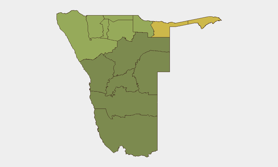
Namibia remains a low-threat environment globally (rank #109, composite score 14) with no tracked major security events as of 23 August 2026. However, subnational risk is concentrated in the northern border regions—Zambezi, Kavango East, and Kavango West—where scores exceed 58, reflecting cross-border movement, wildlife trafficking, and localized resource disputes. Routine crime, including violent incidents and road safety violations, continues across the country at baseline levels.
Key Developments
- C24 Road, Hardap Region (22 August, reported 23 August): A truck driver was arrested for driving under the influence at approximately 04:43 near Rehoboth–Klein Aub, underscoring ongoing road-safety enforcement and DUI-related collision risk on this major corridor.
- Liselo, Katima Mulilo Rural Constituency, Zambezi Region (22 August, reported 23 August): A two-year-old drowned in a residential fish pond at a family home, indicating persistent water-safety hazards in households in high-risk northern regions.
- Okahandja, Central Region (19 August): A man was killed in a spear attack during a dispute over a stolen mobile phone, exemplifying interpersonal violence escalation in smaller towns outside Windhoek.
- National Police Operations (22–23 August): Weekend crime reports from the Namibian Police highlighted multiple DUI arrests across multiple locations, reflecting sustained enforcement operations and ongoing road-safety risk.
- Inspector General of Police Status (23 August, Windhoek): The Security Commission submitted a recommendation to the President regarding the future of suspended Inspector General Joseph Shikongo (suspended in May following a State House security breach). This institutional development affects command-level security governance and may influence operational priorities.
Highest-Risk Areas
Zambezi Region (risk 68) and the two Kavango regions (East 62, West 58) dominate subnational threat rankings, driven by proximity to Angola and Zambia, permeable borders facilitating cross-border crime and trafficking, and limited law enforcement density. Kunene Region (52) adds northwestern exposure to similar border dynamics. Together, these four regions account for the majority of Namibia's internal security concern and should be the primary focus of duty-of-care and asset-protection planning. By contrast, central and southern regions—Erongo, Hardap, Omaheke—show materially lower but non-negligible scores (28–32), reflecting petty crime and road safety rather than organized or cross-border threats.
How GeoBit Would Assist
Corporate security teams with personnel or assets in Namibia's high-risk regions (especially Zambezi and Kavango) should employ AOI Monitoring & Early Warning on specific towns, checkpoints, and travel corridors to detect emerging crime clusters or unrest signals. Routing & Network Analysis is critical for identifying safer alternative routes along the C24 and other high-traffic roads, particularly given elevated DUI enforcement and accident risk. Integration of OSINT fusion (Namibian Police crime reports, local news wires, and radio SIGINT from border patrols) enables real-time threat trending and supports incident response protocols.
7-Day Outlook
No major escalation is anticipated over the next week. Routine crime—petty theft, vehicular incidents, and interpersonal violence—will likely continue at baseline rates. Northern border regions will remain elevated due to structural factors (cross-border movement, trafficking routes), but no specific trigger events are forecast. Standard duty-of-care protocols and regional risk avoidance should remain in effect.
Highest-Risk Areas — Ranked
| # | State / Region | Risk |
|---|---|---|
| 1 | Zambezi | 68 |
| 2 | Kavango East | 62 |
| 3 | Kavango West | 58 |
| 4 | Kunene Region | 52 |
| 5 | Oshikoto | 48 |
| 6 | Ohangwena | 45 |
| 7 | Omusati | 42 |
| 8 | Oshana | 40 |
| 9 | Otjozondjupa | 35 |
| 10 | Erongo Region | 32 |
| 11 | Hardap | 28 |
| 12 | Omaheke | 25 |
Sources
Previous Daily Briefs
A new Namibia brief is written every day — each with its own risk map and downloadable CSV. Here's the last week; use the calendar to go further back.
- August 21, 2026
- August 19, 2026
- August 17, 2026
- August 15, 2026
- August 13, 2026
- August 11, 2026
- August 9, 2026
📅 Browse every day by calendar →
Highlighted days have a brief. Tap a day for that day's map & analysis, or “csv” for that day's dataset ($5).
Atlas — our AI intelligence desk — emails them this snapshot personally. Nothing else, no list.