Situation Summary
Norway remains a low-threat environment (global rank #49, composite score 35), with no 0-day active mass-casualty events as of 20 August 2026. However, recent signals indicate elevated risk in the capital region and surrounding counties, driven by infrastructure vulnerabilities (municipal cyber exposure, transport disruptions), isolated violent incidents, and environmental hazards. The security posture is stable but fragmented across geographies and threat vectors.
Key Developments
- Lillesand, Agder – residential explosion with serious injury (20 August 2026, early morning). Emergency services responded to an explosion at a private address in Borkedalen housing estate, southern Norway. A male in his 40s sustained serious burn injuries and was airlifted to hospital. Police initiated investigation into cause; no criminal attribution confirmed at time of reporting.
- Air traffic controller strike alert (scheduled 21 August 2026). Mediation talks commenced 19 August between air traffic controllers and employer at National Mediator's Office; strike scheduled to commence 21 August, with potential for domestic and international flight disruptions.
- Forest-fire risk – Østlandet and Agder (18 August, ongoing). Yellow-level warnings remain in effect across eastern and southern regions. Authorities advise against open fires due to rapid vegetation ignition risk; no major active fires reported as of 20 August.
- Fagernestunnelen closure – E6 highway, northern corridor (19 August, resolved). Temporary two-way traffic restrictions cleared as of 06:00 on 19 August; road works complete.
Highest-Risk Areas
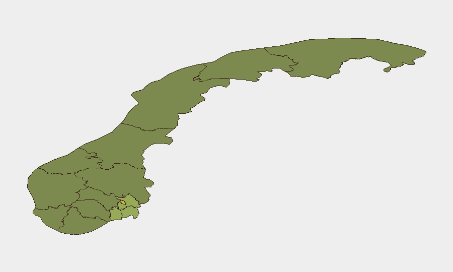
Oslo dominates the risk profile (score 68), driven by cyber-exposure incidents (municipal data breaches at Lørenskog and Oslo University Hospital in mid-August, affecting thousands of residents and child welfare records), kidnapping and violent-crime signals, and concentration of critical infrastructure. Akershus (score 52) and Østfold (score 48) show elevated secondary risk, primarily from proximity to the capital, environmental hazards (forest fire warnings), and scattered violent incidents. The southern and central regions (Rogaland, Buskerud, Trøndelag) present lower but sustained baseline risk; northern areas remain lowest-risk.
How GeoBit Would Assist
Intel Sweep and OSINT Fusion would monitor municipality and healthcare-sector cyber-security disclosures, labor negotiations affecting critical transport, and environmental alerts in real time. AOI Monitoring & Early Warning on Oslo, Akershus, and Østfold would detect emerging clusters of violent crime, protest activity, or infrastructure failures. Risk & Threat Assessment modeling would flag second-order impacts of the air traffic controller strike on supply chains, personnel movement, and business continuity for organizations with Norwegian operations.
7-Day Outlook
The air traffic controller strike (commencing 21 August) poses the single highest operational risk over the next seven days, with potential cascading effects on regional transport and logistics. Forest-fire warnings are expected to persist through late August as dry conditions continue; no major escalation is anticipated absent rapid temperature spike or drought intensification. Violent crime and cyber-targeting of municipal systems remain episodic but warrant continued monitoring in Oslo and surrounding counties; no organized campaign indicators are evident at present.
Highest-Risk Areas — Ranked
| # | State / Region | Risk |
|---|---|---|
| 1 | Oslo | 68 |
| 2 | Akershus | 52 |
| 3 | Østfold | 48 |
| 4 | Vestfold | 42 |
| 5 | Rogaland | 38 |
| 6 | Buskerud | 35 |
| 7 | Trøndelag | 32 |
| 8 | Telemark | 28 |
| 9 | Vestland | 27 |
| 10 | Agder | 26 |
| 11 | Møre og Romsdal | 22 |
| 12 | Innlandet | 20 |
Sources
Previous Daily Briefs
A new Norway brief is written every day — each with its own risk map and downloadable CSV. Here's the last week; use the calendar to go further back.
- August 19, 2026
- August 18, 2026
- August 17, 2026
- August 16, 2026
- August 15, 2026
- August 14, 2026
- August 13, 2026
📅 Browse every day by calendar →
Highlighted days have a brief. Tap a day for that day's map & analysis, or “csv” for that day's dataset ($5).
Atlas — our AI intelligence desk — emails them this snapshot personally. Nothing else, no list.