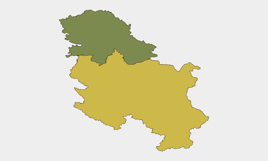
Situation Summary
Serbia remains at composite threat level 19 globally (#87), driven primarily by civil-unrest risk rather than current active violence. Over the past 48 hours, the dominant security event has been an uncontrolled wildfire in the Deliblato Sands region east of Belgrade, which has consumed over 3,500 hectares and prompted EU civil-protection mobilization and Russian emergency-aircraft support. A serious fatal traffic crash in Šimanovci on 27 August and several localized fires (warehouse in Novi Sad, building near the Serbian government) have added to operational disruption, though no organized political unrest, terrorism, or major crime incidents are currently reported in live feeds.
Key Developments
- Deliblato Sands wildfire (27 August) — Suppression operations continuing with Russian emergency aircraft conducting multiple water drops; affected area exceeds 3,500 hectares per EU civil-protection reports; evacuations ongoing in nearby rural communities and disruption to regional road networks.
- Šimanovci fatal crash (27 August) — One person killed and another severely injured requiring urgent transfer to Belgrade; cause under investigation; signals elevated road-safety risk during current operational stress period.
- Belgrade government-building vicinity fire (26 August) — Fire in building across from Serbian government headquarters; initial cause attributed to air-conditioning unit malfunction; contained by emergency response; no casualties reported.
- Novi Sad warehouse fire (25–26 August) — Courier-company facility fire resulted in two minor burn injuries; described as localized; no wider impact on city operations.
- Vranje and Prokop firefighting operations (27 August) — Russian emergency aircraft also deployed to Vranje and Prokop areas, indicating wildfire response spread beyond initial Belgrade-region perimeter and suggesting multiple fire zones across south-central and eastern Serbia.
- Kosovo-Serbia border incident (22–23 August, background) — Fireball incendiary device launched from Kosovo territory and recovered near Brnjak; represents most serious cross-border event in current reporting cycle; no casualties.
- Abduction and torture in New Belgrade (21 August, background) — Man abducted, bound, and tortured over multiple days; one suspect at large; investigation ongoing; reflects organized-crime activity.
Highest-Risk Areas
Central Serbia (composite risk 65) dominates the sub-national ranking and is currently the locus of wildfire disruption, traffic incidents, and scattered structural fires. Vojvodina (risk 35) shows secondary risk and experienced the Novi Sad warehouse fire but remains more stable overall. The wildfire concentration east of Belgrade and the recent fatal crash in Šimanovci suggest that near-term risk in Central Serbia is driven by natural-disaster response strain and secondary-effect incidents (traffic, fires) rather than organized violence, though the cross-border incendiary device and outstanding criminal investigation indicate latent organized-crime and border-security tensions that could escalate if unresolved.
How GeoBit Would Assist
Corporate teams would deploy AOI Monitoring & Early Warning on the Deliblato Sands region, Belgrade, and Vojvodina to track wildfire spread, road closures, and evacuation zones in real-time. Routing & Network Analysis would enable identification of alternative transport corridors and supply-chain workarounds as regional road disruption persists. OSINT Fusion (multi-language social-media, news feeds, and entity extraction) would provide 24-hour tracking of organized-crime, border-incident, and civil-unrest signals that underpin the composite threat score, ensuring early warning of escalation beyond current fire-response operations.
7-Day Outlook
Wildfire suppression is expected to continue for 7–10 days with international support, keeping Central Serbia under elevated operational disruption; road and air-transport bottlenecks likely. Secondary incidents (traffic, structural fires) may rise due to stretched emergency-response capacity. No immediate escalation of organized violence or political unrest is signaled, but the outstanding criminal investigation and Kosovo-border tension warrant continued monitoring.
Highest-Risk Areas — Ranked
| # | State / Region | Risk |
|---|---|---|
| 1 | Central Serbia | 65 |
| 2 | Vojvodina | 35 |
Sources
Previous Daily Briefs
A new Serbia brief is written every day — each with its own risk map and downloadable CSV. Here's the last week; use the calendar to go further back.
- August 25, 2026
- August 23, 2026
- August 21, 2026
- August 19, 2026
- August 17, 2026
- August 15, 2026
- August 13, 2026
📅 Browse every day by calendar →
Highlighted days have a brief. Tap a day for that day's map & analysis, or “csv” for that day's dataset ($5).
Atlas — our AI intelligence desk — emails them this snapshot personally. Nothing else, no list.