Situation Summary
Tunisia remains at composite threat rank #72 globally (score 24), with civil unrest as the primary driver. The security environment is characterized by elevated fire and emergency incident rates, localized armed crime, and ongoing police enforcement operations in urban centers, combined with persistent regional instability in western and southern governorates. No major security escalation has occurred in the past 24–48 hours, but underlying risk drivers—forest fires, transport disruptions, and civil tensions—remain active.
Key Developments
- Jendouba & Siliana (12–13 Aug) – Forest fire in the Jbel Lqna area of Jendouba continues to spread into adjacent mountainous terrain in Siliana; authorities remain engaged in containment efforts.
- Tunis metropolitan area (12 Aug) – Police coordinated a major crime sweep across Bab Souika, El Hafsia, Bab El Akouas, El Halfouine, and Torbet El Bey districts, detaining 26 suspects wanted on arrest warrants and for prison violations.
- Nationwide (10–11 Aug) – Civil protection recorded 628 emergency interventions in 24 hours, including 106 fire responses and numerous road rescues, reflecting high ambient emergency demand.
- Hammamet Nord, Nabeul (6 Aug) – Armed robbery of a currency-exchange bureau; attacker used a bladed weapon to seriously injure the manager and stole cash; a second suspect was identified as accomplice. Video circulated on social media; investigation ongoing.
- Carthage, Tunis (11 Aug) – Hundreds of police staged a pay protest outside the presidential palace after salary-increase negotiations stalled, signaling labor friction within security forces.
- Nationwide (7–9 Aug) – Civil protection reported 1,951 interventions over the weekend, including 397 fire responses, 577 road rescues, and 44 beach operations—sustained high emergency activity.
- Coastal highway, Tripoli–Tunisia border (4 Aug) – Main westbound corridor remains closed due to active security operations and armed clashes; logistics and supply chains disrupted.
Highest-Risk Areas
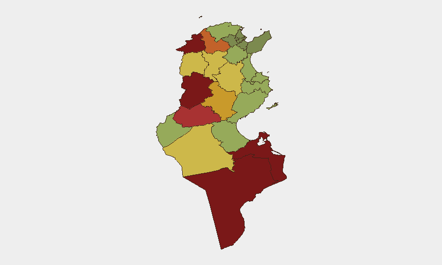
Kasserine (risk 92), Jendouba (88), and Tataouine (85) are the three highest-risk governorates, driven by a combination of armed activity, border proximity, and resource-related tensions. Gafsa (78) faces acute environmental and industrial hazards following the 9 August phosphate facility pollution event that hospitalized over 200 civilians. Western and southwestern regions (Kasserine, Jendouba, Gafsa, Médenine, Tataouine) consistently rank highest due to ongoing security operations, historical militant activity, and logistics vulnerabilities; personnel and asset concentration in these zones should be treated as elevated-risk.
How GeoBit Would Assist
OSINT & Intel Sweep should monitor police enforcement operations, labor unrest, and emerging armed activity across high-risk western and southern governorates in real time. AOI Monitoring & Early Warning would enable persistent watch on Kasserine, Jendouba, and Gafsa to detect escalations in clashes, security sweeps, or industrial incidents before they impact corporate operations. Routing & Network Analysis would identify alternative transport corridors and assess border-crossing viability as the Tripoli–Tunisia coastal highway closure persists, supporting supply-chain continuity planning.
7-Day Outlook
No major escalation is imminent, but fire season, ongoing police sweeps, and regional security operations will likely sustain elevated incident rates through mid-August. The coastal highway closure may remain in effect; organizations should plan alternative logistics routing. Labor friction in security forces and civil unrest triggers (water/electricity shortages) remain latent; sustained monitoring of Tunis and western governorates is warranted.
Highest-Risk Areas — Ranked
| # | State / Region | Risk |
|---|---|---|
| 1 | Kasserine | 92 |
| 2 | Jendouba | 88 |
| 3 | Tataouine | 85 |
| 4 | Médenine | 83 |
| 5 | Gafsa | 78 |
| 6 | Béja | 75 |
| 7 | Sidi Bouzid | 72 |
| 8 | Al Kaf | 70 |
| 9 | Kébili | 68 |
| 10 | Kairouan | 65 |
| 11 | Siliana | 62 |
| 12 | Tozeur | 58 |
Sources
Previous Daily Briefs
A new Tunisia brief is written every day — each with its own risk map and downloadable CSV. Here's the last week; use the calendar to go further back.
📅 Browse every day by calendar →
Highlighted days have a brief. Tap a day for that day's map & analysis, or “csv” for that day's dataset ($5).
Atlas — our AI intelligence desk — emails them this snapshot personally. Nothing else, no list.