Situation Summary
Burkina Faso remains classified as the 20th-highest threat country globally (composite score 75), driven primarily by active insurgency. Over the past 48 hours, the military reported coordinated jihadist attacks across multiple northern positions (6–7 July), claiming over 400 combatants killed in counteroffensives. Concurrent with military escalation, authorities have implemented new humanitarian-sector regulations and intensified internal security posture in the capital, while civic-space restrictions on journalists, opposition figures, and human-rights defenders remain acute. The country's rupture with France has amplified political volatility and retaliatory-risk messaging in state-aligned media.
Key Developments
- Kossi Province and northern military positions (6–7 July 2026): Burkina Faso's military announced repulsion of coordinated attacks on multiple bases across Kossi Province and adjoining areas, claiming 400+ attackers killed and citing air-support operations. Claims were amplified via Anadolu Agency and TRT World social feeds within 24 hours of announcement.
- Multi-location northern assault pattern (6–7 July 2026): State media and pro-government social accounts reported simultaneous strikes on army positions across northern Burkina Faso, indicating a coordinated multi-base attack rather than isolated incident.
- Ouagadougou security reinforcement (7 July 2026): Visible tightening of military checkpoints, patrols, and internal-security posture documented in pro-government social-media posts; framed as response to northern attacks and broader AES-aligned counter-insurgency operations.
- Nationwide NGO regulation (announced by 7 July 2026): Burkinabè authorities issued new restrictions on humanitarian agencies, banning display or sharing of "degrading" images of aid recipients, effective across all humanitarian operations and potentially affecting access and reporting.
- Elevated civic-space repression (highlighted 7 July 2026): Rights advocates' social-media content reinforces that journalists, students, opposition figures, and human-rights defenders face ongoing arbitrary arrests, intimidation, and enforced disappearances; political-party and civil-society suspensions remain in effect.
- Political-retaliatory messaging (early July 2026): State and pro-government commentary emphasize France-rupture fallout and heightened public hostility toward perceived foreign influence, contributing to short-term business and travel-security volatility.
Highest-Risk Areas
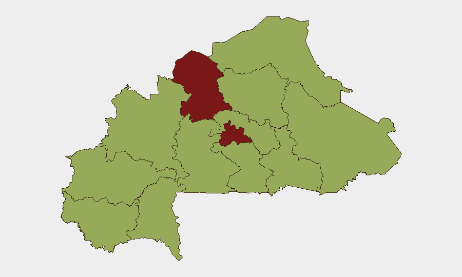
North and Centre regions drive the composite-threat ranking (both 82.7), reflecting active armed-group presence, repeated military operations, and logistics for insurgent activity. The remaining ten regions cluster at 52.7 risk, indicating broad territorial instability across Sahel, Upper-Basins, and eastern zones, though North and Centre remain the primary conflict and casualty zones. Northern Kossi Province's recent multi-base attack signals sustained insurgent capability and coordination despite military claims of heavy casualties.
How GeoBit Would Assist
Security teams would employ AOI Monitoring & Early Warning on North and Centre regions to detect follow-on attack patterns or displacement; OSINT fusion and network analysis to corroborate military casualty claims and track armed-group communications across X, Telegram, and regional media; and conflict & military battle mapping to assess force positions and operational tempo. Humanitarian & NGO data capabilities would track implementation and impact of new aid-sector regulations on ground access and staffing. Routing & network analysis would support alternative-route planning for staff and asset movement in and out of high-risk areas.
7-Day Outlook
The 6–7 July coordinated attacks suggest insurgent groups retain capacity to mount multi-location assaults despite military air support. Expect sustained military operations, elevated checkpoints in urban centers, continued civic-space restrictions, and heightened scrutiny of humanitarian and foreign-linked entities. Further attacks or civilian-casualty incidents in North or Centre regions within seven days would likely trigger additional security restrictions and reinforce capital-level lockdowns.
Highest-Risk Areas — Ranked
| # | State / Region | Risk |
|---|---|---|
| 1 | North | 82.7 |
| 2 | Centre | 82.7 |
| 3 | Upper-Basins | 52.7 |
| 4 | Boucle du Mouhoun | 52.7 |
| 5 | Central-West | 52.7 |
| 6 | Central-South | 52.7 |
| 7 | Central-East | 52.7 |
| 8 | Waterfalls | 52.7 |
| 9 | Southwest | 52.7 |
| 10 | Sahel | 52.7 |
| 11 | Central-North | 52.7 |
| 12 | East | 52.7 |
Sources
Previous Daily Briefs
A new Burkina Faso brief is written every day — each with its own risk map and downloadable CSV. Here's the last week; use the calendar to go further back.
📅 Browse every day by calendar →
Highlighted days have a brief. Tap a day for that day's map & analysis, or “csv” for that day's dataset ($5).
Atlas — our AI intelligence desk — emails them this snapshot personally. Nothing else, no list.