Situation Summary
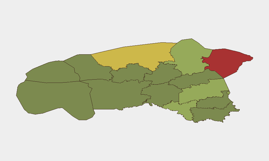
Estonia remains a low-threat country (global rank #111, composite score 13) with no tracked security events in the current reporting period. However, recent developments indicate heightened border-security posture along the Russian frontier, driven by drone incursions across the wider Baltic-Finnish region and new NATO air activity. Ida-Viru County, which includes the Narva border zone, carries significantly elevated risk (score 78) relative to the national baseline, reflecting proximity to Russia and historical cross-border tensions. The security environment is stable but increasingly monitored.
Key Developments
- Narva / Narva-Jõesuu border area, 2026-08-15: Estonia commissioned new drone-detection radars on the Russian border between Narva and Narva-Jõesuu to improve rapid detection of unmanned aerial vehicles, reflecting a response to regional UAV activity.
- Estonia–Russia border checkpoints, 2026-08-13 to 2026-08-15: The government extended indefinite operation of limited road and railway checkpoints on the eastern border, citing border-security and incident-response readiness.
- Eastern Estonia / Narva River border zone, 2026-08-15: A new drone surveillance system was deployed on the Narva River to reinforce monitoring along the eastern border.
- NATO air activity over Estonia, 2026-08-10 to 2026-08-15: The Estonian Defence Forces conducted routine allied air training flights in Estonian airspace, consistent with scheduled NATO operations.
- Eastern Gulf of Finland / regional airspace, 2026-08-14: Temporary air- and maritime-traffic restrictions were implemented in the eastern Gulf of Finland following drone activity in the wider region, affecting Estonia's coastal security perimeter and travel corridors.
- Baltic-Finnish border drone incursions, 2026-08-14: Reuters reported heightened concern over drone incursions across NATO's Baltic-Finnish border region, with Estonia part of the broader security response; framed as a regional travel and security-risk development rather than a domestic incident within Estonia.
Highest-Risk Areas
Ida-Viru County dominates Estonia's sub-national risk profile (score 78), driven by direct proximity to Russia and the Narva border crossing—a traditional point of tension and cross-border activity. Harju County (score 68), home to Tallinn and Estonia's capital infrastructure, carries secondary risk reflecting concentration of government, finance, and transport assets. Tartu and Valga counties (scores 58 and 55) remain moderately elevated. The eastern tier of counties collectively reflects border proximity and historical migration/transit flows; western and southern regions carry minimal risk.
How GeoBit Would Assist
Corporate security teams would deploy AOI Monitoring & Early Warning on Ida-Viru County and the Narva River border zone to detect drone activity, checkpoint changes, and cross-border incidents in real time. Intel Sweep capabilities—combining global event feeds, OSINT fusion, and multi-language search—enable continuous tracking of Russian-border developments and NATO air posture without manual web crawling. Routing & Network Analysis supports duty-of-care teams planning safe travel corridors and alternative routes in high-risk border areas or around checkpoint delays.
7-Day Outlook
Estonia's security posture will likely remain elevated along the Russian border as drone-detection and surveillance infrastructure comes online. Border checkpoint operations and NATO air activity are expected to continue at current levels. No degradation in national security stability is anticipated unless drone incursions intensify or cross-border incidents occur; current developments reflect defensive capability-building rather than an emerging threat to civilian operations or corporate assets.
Highest-Risk Areas — Ranked
| # | State / Region | Risk |
|---|---|---|
| 1 | Ida-Viru County | 78 |
| 2 | Harju County | 68 |
| 3 | Tartu County | 58 |
| 4 | Valga County | 55 |
| 5 | Lääne-Viru County | 52 |
| 6 | Pärnu County | 35 |
| 7 | Rapla County | 32 |
| 8 | Jõgeva County | 30 |
| 9 | Järva County | 28 |
| 10 | Viljandi County | 25 |
| 11 | Põlva County | 22 |
| 12 | Võru County | 18 |
Sources
Previous Daily Briefs
A new Estonia brief is written every day — each with its own risk map and downloadable CSV. Here's the last week; use the calendar to go further back.
- August 13, 2026
- August 11, 2026
- August 9, 2026
- August 7, 2026
- August 6, 2026
- August 5, 2026
- August 4, 2026
📅 Browse every day by calendar →
Highlighted days have a brief. Tap a day for that day's map & analysis, or “csv” for that day's dataset ($5).
Atlas — our AI intelligence desk — emails them this snapshot personally. Nothing else, no list.