Situation Summary
Ivory Coast remains at moderate, stable threat level (rank #60 globally, composite score 32) with no major security incidents reported in the last 24–48 hours (30–31 August 2026). The primary driver remains low-level insurgency/terrorism risk concentrated in the northern border districts. Underlying socio-economic tensions—including illegal mining disputes, fiscal grievances, and opposition political actions—persist but have not escalated into widespread violence in recent days.
Key Developments
No clearly documented security, unrest, or violent incidents specific to Ivory Coast territory have entered international or regional reporting channels for 30–31 August 2026. Web research confirms active reporting on regional events (notably military clashes in Niamey, Niger on 29 August), but no parallel incidents within Ivory Coast proper are evident in available feeds.
Context (prior 7 days):
- 25 August, Illegal Mining Sites (location unspecified): Local populations clashed with gendarmerie conducting anti-illegal-mining enforcement, signalling community resistance to security operations targeting artisanal mining.
- 24 August, Bodana Border Post (Burkina Faso–Ivory Coast border, northern region): Gunfire reported approximately 800 metres from the Ivorian border post, originating from or near the Burkina Faso side; no cross-border spillover into Ivory Coast territory confirmed.
- 23 August, Prefecture Construction Site (district not specified): Armed robbery of an under-construction prefecture; electrical wiring valued ~150 million FCFA stolen. Indicates organized property crime in provincial areas.
- 26 August, Gbon, Bagoué Region (northern Ivory Coast): Government security assessment visit; official briefing noted security situation reported as "under control" and security forces commended for professionalism.
Highest-Risk Areas
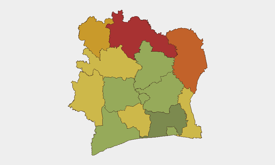
Northern border districts drive the national risk ranking. Savanes, Zanzan, Denguélé, and Comoé districts (risk scores 78, 75, 72, 70 respectively) account for the composite threat elevation, reflecting proximity to Burkina Faso instability, cross-border militant activity, and limited state presence. Montagnes District (risk 68) shares similar exposure. These five regions are geographically contiguous to Sahel conflict zones and account for the majority of terrorism/insurgency risk. Southern and central districts—including Abidjan (risk 45)—carry substantially lower threat profiles linked mainly to urban crime and socio-economic friction.
How GeoBit Would Assist
Security teams operating in Ivory Coast should employ AOI Monitoring & Early Warning on the five highest-risk northern districts (Savanes, Zanzan, Denguélé, Comoé, Montagnes) with persistent alert thresholds for cross-border activity and militant movement. Intel Sweep and multi-language OSINT (X/Twitter, Telegram, regional news feeds) provide real-time event corroboration and sentiment tracking to distinguish signal from noise and detect emerging unrest before mainstream reporting. GIS & Spatial Analysis and Routing & Network Analysis enable duty-of-care teams to plan secure travel corridors, identify safe havens, and avoid high-risk nodes in operational areas.
7-Day Outlook
No escalation in national-level security incidents is forecast for the next week absent exogenous shocks (e.g., major cross-border spillover from Burkina Faso). Local tensions around illegal mining and property crime are likely to remain sporadic and manageable. Continued low-level border activity and gendarmerie enforcement operations in provincial areas should be expected as baseline conditions.
Highest-Risk Areas — Ranked
| # | State / Region | Risk |
|---|---|---|
| 1 | Savanes District | 78 |
| 2 | Zanzan District | 75 |
| 3 | Denguélé District | 72 |
| 4 | Comoé District | 70 |
| 5 | Montagnes District | 68 |
| 6 | Woroba District | 65 |
| 7 | Gôh-Djiboua District | 60 |
| 8 | Sassandra-Marahoué District | 58 |
| 9 | Vallée du Bandama District | 55 |
| 10 | Bas-Sassandra District | 52 |
| 11 | Lacs District | 48 |
| 12 | Abidjan | 45 |
Sources
Previous Daily Briefs
A new Ivory Coast brief is written every day — each with its own risk map and downloadable CSV. Here's the last week; use the calendar to go further back.
- August 30, 2026
- August 28, 2026
- August 26, 2026
- August 25, 2026
- August 23, 2026
- August 21, 2026
- August 20, 2026
📅 Browse every day by calendar →
Highlighted days have a brief. Tap a day for that day's map & analysis, or “csv” for that day's dataset ($5).
Atlas — our AI intelligence desk — emails them this snapshot personally. Nothing else, no list.