Situation Summary
Maldives remains a low-threat environment globally (rank #151, composite score 6), with no tracked security events in the 24-hour window. However, multiple concurrent incidents—a maritime disaster with three missing persons, planned political protests in Malé, and ongoing counter-narcotics operations—reflect underlying vulnerabilities in maritime safety, political polarization, and drug-trafficking exposure. The country's dispersed atoll geography and dependence on maritime transport create persistent operational risks, particularly in the capital and northern atolls.
Key Developments
- Malé, 2026-08-14 — The Maldivian Democratic Party (MDP) announced plans for a mass protest over rising dollar rates; the Home Minister stated the demonstration cannot be held on Majeedhee Magu, signaling potential permit/access restrictions and heightened police presence in the city center.
- Malé Parliament, 2026-08-14 — The MDP submitted a motion of no confidence against the Minister of Economic Development and Trade, escalating political friction and suggesting sustained opposition pressure on economic governance.
- Gaafu Alif Atoll (Kudalafari vicinity), 2026-08-13–2026-08-14 — The supply vessel *Friend 4* capsized approximately 4.1 nautical miles off Kudalafari; seven of eight crew were rescued, but three men remain missing after extensive MNDF air-and-sea search operations across >7,500 nautical miles by air and 1,970 by sea, with no survivors yet located.
- Huvadhoo Sea, 2026-08-14 — Ongoing search-and-rescue operations for the three missing crew members continued without positive sightings, reflecting the maritime hazard profile in south-central atolls and the strain on emergency-response capacity.
- West of Nolhivaranfaru, 2026-08-13–2026-08-14 — A diving dhoni named *Urafaa* ran aground on a reef; six persons were rescued and brought ashore, indicating recurring maritime incidents in northern waters.
Highest-Risk Areas
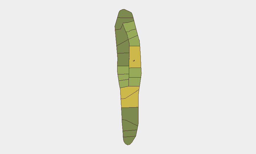
Malé and Malé Atoll (risk scores 85 and 68 respectively) dominate the sub-national ranking, driven by political activity, law enforcement operations, and population density. Hadhdhunmathi, Kolhumadulu, and Felidhu Atoll (scores 65, 60, 58) form a secondary tier in the northern and central regions, where drug-smuggling arrests and maritime traffic create layered exposure. The concentration of risk in the capital reflects both legitimate governance friction and organized-crime activity; northern atolls face maritime safety and trafficking-related pressures. Southern atolls (scores 40–48) register lower but still material risk, as evidenced by the *Friend 4* incident in Gaafu Alif.
How GeoBit Would Assist
Security teams should deploy AOI Monitoring & Early Warning on Malé and northern atoll transit routes to track planned protests, police operations, and maritime incidents in real time. OSINT Fusion & Corroboration on MDP and opposition messaging, combined with Sentiment & Temporal Analysis, will provide early signals of escalating political tension or protest scope. Maritime & Aviation Tracking, paired with GIS & Spatial Analysis, enables predictive routing and emergency-response coordination for personnel or supply movements across atolls and open water.
7-Day Outlook
Political pressure on economic policy is likely to sustain street-level demonstration activity in Malé over the near week, with potential for transport and commerce disruption if protests expand. Maritime incidents will remain a baseline risk given monsoon seasonality and atoll geography; no security escalation is expected beyond current counter-narcotics enforcement and political contestation. Overall threat trajectory remains low to moderate, contingent on protest scale and any adverse maritime weather.
Highest-Risk Areas — Ranked
| # | State / Region | Risk |
|---|---|---|
| 1 | Malé | 85 |
| 2 | Malé Atoll | 68 |
| 3 | Hadhdhunmathi | 65 |
| 4 | Kolhumadulu | 60 |
| 5 | Felidhu Atoll | 58 |
| 6 | Mulaku Atoll | 55 |
| 7 | Faadhippolhu | 52 |
| 8 | South Miladhunmadulu | 48 |
| 9 | North Miladhunmadulu | 45 |
| 10 | South Nilandhe Atoll | 44 |
| 11 | North Nilandhe Atoll | 42 |
| 12 | South Ari Atoll | 40 |
Sources
Previous Daily Briefs
A new Maldives brief is written every day — each with its own risk map and downloadable CSV. Here's the last week; use the calendar to go further back.
- August 12, 2026
- August 10, 2026
- August 8, 2026
- August 6, 2026
- August 5, 2026
- August 4, 2026
- August 3, 2026
📅 Browse every day by calendar →
Highlighted days have a brief. Tap a day for that day's map & analysis, or “csv” for that day's dataset ($5).
Atlas — our AI intelligence desk — emails them this snapshot personally. Nothing else, no list.