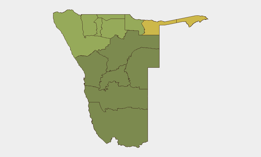
Situation Summary
Namibia remains a stable, low-threat environment with a composite threat score of 14 and no tracked security incidents in the current reporting window. The country's security posture has not changed materially in the last 24–48 hours. Risk remains concentrated in the northern border regions—particularly Zambezi, Kavango East, and Kavango West—where cross-border activity, resource competition, and limited state presence create persistent vulnerabilities; however, no acute escalation has been reported.
Key Developments
No discrete security, civil unrest, or travel-risk incidents were corroborated in Namibia in the last 24–48 hours. Recent web research surfaced routine government, infrastructure, and cultural reporting:
- Windhoek, 24 Aug — Presidential reinterment ceremony for liberation fighters held at Heroes' Acre; ceremonial and historical in nature, no security implications.
- Windhoek, 24 Aug — Municipal land-purchase reporting relating to an older State House intrusion incident; no new security event in the last 48 hours.
- Ondangwa/Oshikango corridor, 24 Aug — Infrastructure partnership MoU signed between CRAN and NORED; routine development activity.
- Ongwediva, 24 Aug — Annual Trade Fair coverage; non-security event.
- Kunene Region, 24 Aug — Humanitarian alerts issued regarding food insecurity and water shortage; ongoing chronic conditions, not acute incidents.
Assessment: The absence of reportable security events underscores Namibia's current stability. Monitoring should remain focused on the high-risk northern regions rather than response to active disturbances.
Highest-Risk Areas
Zambezi Region (risk 68) and the two Kavango regions (East, 62; West, 58) account for the bulk of national risk and warrant primary focus. These areas are characterized by porous borders with Angola and Zambia, competition over wildlife and artisanal resource extraction, limited state administrative capacity, and historical cross-border movement of armed groups. Kunene Region (52) and Oshikoto (48) present secondary concerns linked to similar border dynamics. The southern and central regions—Hardap, Omaheke, Otjozondjupa, and Erongo—carry significantly lower composite scores and present minimal organized threat to corporate operations.
How GeoBit Would Assist
Corporate security teams should employ AOI Monitoring & Early Warning to establish persistent watch over Zambezi and Kavango regions, with automated alerting triggered by cross-border activity, civilian displacement, or security-force deployment. Intel Sweep and multi-language OSINT fusion across regional news, social media, and local government channels will detect emerging tensions or incidents hours before international wires report them. GIS & Spatial Analysis combined with Routing & Network Analysis enables security teams to identify safe corridors, alternative routes, and real-time asset positioning in high-risk zones, reducing exposure without suspending operations.
7-Day Outlook
No deterioration in Namibia's security environment is forecast for the next seven days. Border-region monitoring should remain routine; however, the approach of the austral spring and increased pastoral and wildlife-movement activity in northern regions may generate localized cross-border friction. Any material change will likely emerge first in regional social media and radio SIGINT rather than formal government or media channels, making persistent OSINT surveillance essential for duty-of-care teams with field operations.
Highest-Risk Areas — Ranked
| # | State / Region | Risk |
|---|---|---|
| 1 | Zambezi | 68 |
| 2 | Kavango East | 62 |
| 3 | Kavango West | 58 |
| 4 | Kunene Region | 52 |
| 5 | Oshikoto | 48 |
| 6 | Ohangwena | 45 |
| 7 | Omusati | 42 |
| 8 | Oshana | 40 |
| 9 | Otjozondjupa | 35 |
| 10 | Erongo Region | 32 |
| 11 | Hardap | 28 |
| 12 | Omaheke | 25 |
Sources
Previous Daily Briefs
A new Namibia brief is written every day — each with its own risk map and downloadable CSV. Here's the last week; use the calendar to go further back.
- August 23, 2026
- August 21, 2026
- August 19, 2026
- August 17, 2026
- August 15, 2026
- August 13, 2026
- August 11, 2026
📅 Browse every day by calendar →
Highlighted days have a brief. Tap a day for that day's map & analysis, or “csv” for that day's dataset ($5).
Atlas — our AI intelligence desk — emails them this snapshot personally. Nothing else, no list.