Situation Summary
Norway remains a low-threat environment (global rank #50) with no tracked systemic security crises, but localized incidents—violent crime, industrial accidents, and cyber intrusions—have clustered in the past week. Oslo and its surrounding regions (Akershus, Østfold) account for disproportionate risk, driven by urban violence and critical infrastructure vulnerability. An air traffic controller strike beginning 21 August will disrupt travel and logistics; the underlying labor dispute carries no militant dimension but will strain duty-of-care planning for personnel mobility.
Key Developments
- Oslo & surrounding region (21 August, ongoing) — National air traffic controllers' strike scheduled to commence; mediation talks between union and employer concluded without agreement on 19 August. Expect flight delays, diversions, and ground-handling disruptions.
- Lillesand, south coast (18 August) — Explosion at a private residential address; male casualty (age 40s) sustained serious burns. Cause under investigation; no immediate security classification disclosed by authorities.
- Lørenskog municipality, east of Oslo (14 August) — Cyberattack on municipal systems exposed resident records and patient files; municipal employee suspected of involvement. Represents data-integrity breach in local government infrastructure.
- Bærum, near Oslo (15 August) — Two foreign nationals arrested after unauthorized drone activity over Kolsås military camp, a restricted airspace zone. Indicates either surveillance probe or inadvertent violation; investigation ongoing.
- Multiple violence incidents (16–18 August, scattered) — Three separate stabbing incidents reported (Breistein/Ytre Arna, Harstad, unnamed location); a 50+ year-old and a 20-something arrested respectively. Incidents consistent with alcohol-fueled altercations rather than organized violence.
- Ulsteinvik, Ørsta, Volda, Sunnmøre region (16 August) — Multiple noise and drunk-behavior incidents reported overnight; police response elevated but no serious injuries or weapons use noted.
- Hvaler, Skagerrak offshore (10 August) — Sulphuric acid tanker *Bergstraum* (124 m) suffered explosion and fire during welding operations. Contained to industrial accident; no immediate threat to coastal population, though marine hazmat recovery warranted monitoring.
Highest-Risk Areas
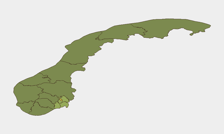
Oslo (risk 68) dominates the national profile, reflecting both population density and higher rates of urban street violence and petty crime. The eastern corridor—Akershus (52), Østfold (48), Vestfold (42)—clusters around the capital's commuter belt and contains critical transport, logistics, and military installations (e.g., Kolsås camp), creating layered vulnerability to cyber, drone, and conventional criminal activity. Rogaland (38), home to major oil and gas infrastructure, warrants separate monitoring for maritime and industrial hazards. Southern and western regions (Telemark, Vestland, Agder, Møre og Romsdal) show materially lower composite risk and have not featured in recent event signals.
How GeoBit Would Assist
Security teams should deploy AOI Monitoring & Early Warning on Oslo, Akershus, and critical nodes (airports, ports, energy facilities) to detect clustering of violent incidents or infrastructure anomalies in near-real time. Maritime & Aviation tracking combined with Shodan network reconnaissance will provide early signal of unauthorized activity (drone incursions, vessel anomalies) or cyber exposure in critical systems. Routing & Network Analysis enables alternative journey planning during the air traffic strike, while Intel Sweep with multi-language and social-media OSINT will capture labor-movement escalation or secondary protest activity.
7-Day Outlook
The air traffic strike will be the dominant disruptor through at least 26–28 August unless emergency mediation succeeds. Violent street incidents are expected to remain sporadic and localized to urban centers; no indication of organized crime escalation or political violence. Personnel in Oslo and eastern regions should expect routine travel friction and maintain elevated situational awareness in entertainment districts during peak evening hours.
Highest-Risk Areas — Ranked
| # | State / Region | Risk |
|---|---|---|
| 1 | Oslo | 68 |
| 2 | Akershus | 52 |
| 3 | Østfold | 48 |
| 4 | Vestfold | 42 |
| 5 | Rogaland | 38 |
| 6 | Buskerud | 35 |
| 7 | Trøndelag | 32 |
| 8 | Telemark | 28 |
| 9 | Vestland | 27 |
| 10 | Agder | 26 |
| 11 | Møre og Romsdal | 22 |
| 12 | Innlandet | 20 |
Sources
Previous Daily Briefs
A new Norway brief is written every day — each with its own risk map and downloadable CSV. Here's the last week; use the calendar to go further back.
- August 20, 2026
- August 19, 2026
- August 18, 2026
- August 17, 2026
- August 16, 2026
- August 15, 2026
- August 14, 2026
📅 Browse every day by calendar →
Highlighted days have a brief. Tap a day for that day's map & analysis, or “csv” for that day's dataset ($5).
Atlas — our AI intelligence desk — emails them this snapshot personally. Nothing else, no list.