Situation Summary
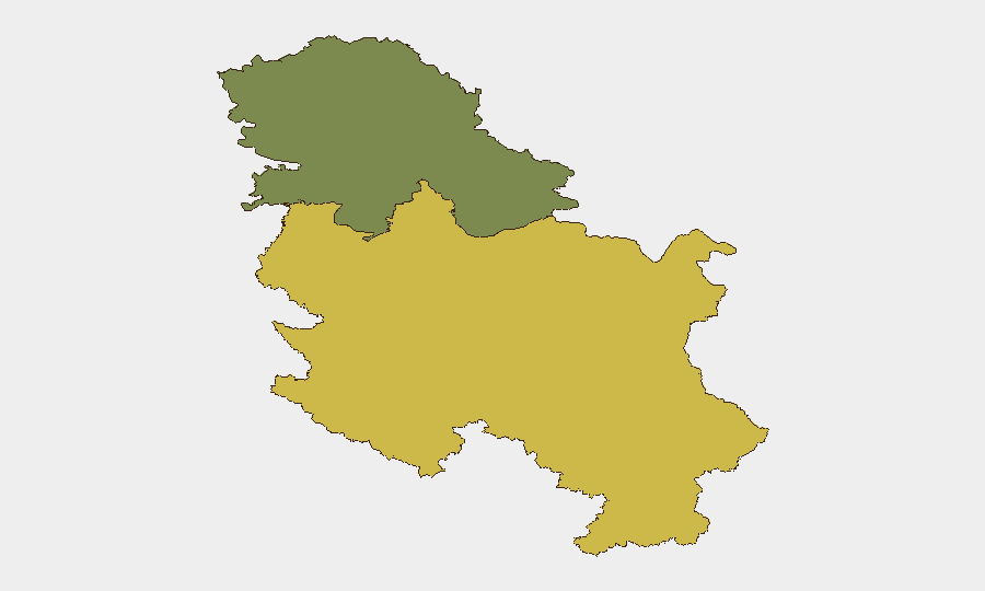
Serbia's composite threat score (19/100, rank #87 globally) reflects manageable overall risk, but localized civil unrest and serious violent crime incidents on 29 August signal elevated volatility in specific areas. Central Serbia (risk score 65) dominates the sub-national threat picture, driven by active wildfires, political tensions, and criminal violence. No systemic security breakdown is indicated, but duty-of-care teams should monitor protest activity, traffic disruptions, and air quality in affected regions over the next 7–10 days.
Key Developments
- Užice, Partizan Square (29 Aug, ~14:00): Police deployed tear gas to disperse protesters ahead of an SNS ruling party rally attended by President Aleksandar Vučić. Reports indicate physical clashes between demonstrators, police, and party stewards; at least one RTS cameraman was injured by a thrown stone. This represents the highest-profile civil unrest signal in the current window.
- Belgrade student road blockades (28 Aug, reported 29 Aug): Student-organized groups blocked traffic at two key points in Belgrade. Short-notice road closures are possible; current status and scale unclear.
- Veliko Gradište homicide (Braničevo District, 29 Aug): A double homicide was reported with forensic investigation underway; motive unknown. Localized police activity; no public security spillover indicated.
- Niš stabbing incident (Borivoja Stevanovića Street, ~14:00, 29 Aug): A 65-year-old man was stabbed in a traffic dispute. The 43-year-old suspect was arrested quickly; incident contained and under investigation with Higher Public Prosecutor notification.
- Kolubara mining basin industrial accident (Radljevo Sever site, morning 29 Aug): A crane cable failed during loading operations, injuring two workers; one fatality. Workplace safety incident with no indication of wider public security impact.
- Nationwide wildfire activity (29 Aug): Approximately 20 active fires reported across Serbia, with a Russian Il-76 aircraft conducting aerial firefighting. Fires near Lebane were extinguished; Vranje fires controlled; Stolovi mountain and Deliblatska peščara under continued monitoring. Strong winds pose re-ignition risk but situation described as more stable than previous days. Potential smoke and localized travel disruption.
Highest-Risk Areas
Central Serbia (score 65) significantly outweighs Vojvodina (score 35) and concentrates risk from multiple vectors: active wildfires with air-quality and evacuation implications; political demonstrations in major urban centers (Užice, Belgrade); and serious interpersonal violent crime (Veliko Gradište homicide, Niš stabbing). Braničevo and Kolubara districts show acute incident clustering. Vojvodina's lower ranking reflects relative stability, though routine vigilance is warranted given proximity to Central Serbia's volatile activity.
How GeoBit Would Assist
Security teams should deploy AOI Monitoring & Early Warning on Užice, Belgrade, and wildfire zones (Stolovi, Deliblatska peščara) to trigger alerts on protest escalation, road blockade formation, or fire-line advancement. Intel Sweep and X/Twitter & Telegram OSINT provide real-time protest signaling and permit schedules; Routing & Network Analysis enables alternate journey planning around student blockades and police perimeters. Environmental & Health monitoring tracks wildfire smoke dispersal and air-quality impacts on operations.
7-Day Outlook
Political tensions around ruling party activity and student-led protest mobilization are likely to persist through early September, with elevated risk of short-notice road closures and tear-gas deployment in Belgrade and central cities. Wildfire operations should stabilize if weather remains favorable, but wind shifts could reignite dispersed sites. No indicators of nationwide destabilization; localized situational awareness and contingency routing remain the primary mitigation measures.
Highest-Risk Areas — Ranked
| # | State / Region | Risk |
|---|---|---|
| 1 | Central Serbia | 65 |
| 2 | Vojvodina | 35 |
Sources
Previous Daily Briefs
A new Serbia brief is written every day — each with its own risk map and downloadable CSV. Here's the last week; use the calendar to go further back.
- August 27, 2026
- August 25, 2026
- August 23, 2026
- August 21, 2026
- August 19, 2026
- August 17, 2026
- August 15, 2026
📅 Browse every day by calendar →
Highlighted days have a brief. Tap a day for that day's map & analysis, or “csv” for that day's dataset ($5).
Atlas — our AI intelligence desk — emails them this snapshot personally. Nothing else, no list.