Situation Summary
Russia conducted a sustained multi-domain offensive across Ukraine on 16 July, combining ballistic missiles, over 200 attack drones, and naval strikes across five major regions. Civilian casualties mounted in Zaporizhzhia and across the southeastern theatre, while air-raid alerts remained active in Kyiv and surrounding areas through the evening. The concurrent intensification of Russian strikes and Ukrainian maritime operations against Russian vessels indicates sustained high-tempo conflict with no immediate de-escalation signals; the security environment remains elevated nationwide.
Key Developments
- Kyiv, Kyiv Oblast – 16 July, morning & evening: Russian forces launched at least eight ballistic missiles in two waves, igniting fires in a storage facility and an unoccupied building across two city districts. Additional air-raid alerts were issued in the evening as part of the broader attack wave, elevating immediate risk to civilian infrastructure and mobility.
- Zaporizhzhia city & Orikhiv area, Zaporizhzhia Oblast – 16 July: Russian strikes killed five civilians—three in Zaporizhzhia city and two in drone strikes near Orikhiv—amid intensified regional attacks, demonstrating sustained targeting of civilian-populated southeastern areas.
- Multi-region drone campaign – 16 July, morning through day: Russia deployed more than 200 Shahed-type attack drones against Zaporizhzhia, Donetsk, Sumy, Kharkiv, and Dnipro oblasts. President Zelensky warned of preparations for additional large-scale strikes and urged civilians to treat air-raid alerts with heightened seriousness.
- Black Sea & Sea of Azov – night of 15–16 July: Ukrainian forces targeted approximately 20 Russian ships, including tankers and logistical support vessels used for oil and petroleum transport, continuing a broader maritime campaign.
- Diplomatic & military escalation signals – 14–15 July: High-impact diplomatic and military signals emerged, including presidential disapproval statements, inter-agency conflict signals, and military force actions, indicating broader institutional stress alongside kinetic operations.
Highest-Risk Areas
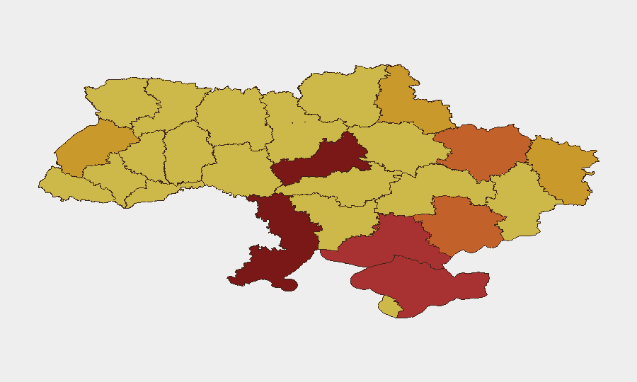
Cherkasy Oblast (risk 100) and Kyiv (99.1) lead the sub-national ranking, driven by proximity to Russian strike capabilities and demonstrated targeting of both capital infrastructure and central-regional civilian areas. Southeastern oblasts—Odesa (82.3), Kherson (78.8), and Zaporizhzhia (74.1)—reflect sustained conventional military operations, naval/maritime threat exposure, and repeated civilian casualty events. Eastern regions (Kharkiv, Luhansk, Sumy) maintain elevated scores owing to proximity to operational frontlines and drone/missile transit corridors. Northern and western oblasts (Lviv, 71.3) remain at secondary but significant risk, reflecting drone dispersion and occasional deep strikes.
How GeoBit Would Assist
Corporate security teams should employ AOI Monitoring & Early Warning to track persistent threat activity in Kyiv, Cherkasy, and Zaporizhzhia, with automated alerting configured for ballistic and drone strikes. Conflict & Military battle mapping combined with GIS & Spatial Analysis enable real-time identification of strike patterns and safe-corridor routing for personnel movement. Early Warning & Prediction leveraging event signals and OSINT fusion (Intel Sweep, Telegram/X OSINT) provide 6–12 hour advance notice of anticipated large-scale strikes, supporting duty-of-care protocols and evacuation triggers.
7-Day Outlook
Russian strike frequency and drone deployment volumes show no signs of contraction; ballistic and Shahed-type attacks are likely to persist or intensify over the next 7 days. Kyiv and central regions should anticipate continued air-raid cycles; southeastern regions face sustained ground and aerial threat. Personnel and asset protection plans should assume sustained high-tempo operations through at least 24 July.
Highest-Risk Areas — Ranked
| # | State / Region | Risk |
|---|---|---|
| 1 | Cherkasy Oblast | 100 |
| 2 | Kyiv | 99.1 |
| 3 | Odesa Oblast | 82.3 |
| 4 | Kherson Oblast | 78.8 |
| 5 | Autonomous Republic of Crimea | 76 |
| 6 | Zaporizhia Oblast | 74.1 |
| 7 | Kharkiv Oblast | 73.6 |
| 8 | Luhansk Oblast | 72.8 |
| 9 | Sumy Oblast | 71.9 |
| 10 | Lviv Oblast | 71.3 |
| 11 | Dnipropetrovsk Oblast | 70.6 |
| 12 | Chernihiv Oblast | 70.6 |
Sources
Previous Daily Briefs
A new Ukraine brief is written every day — each with its own risk map and downloadable CSV. Here's the last week; use the calendar to go further back.
📅 Browse every day by calendar →
Highlighted days have a brief. Tap a day for that day's map & analysis, or “csv” for that day's dataset ($5).
Atlas — our AI intelligence desk — emails them this snapshot personally. Nothing else, no list.