Situation Summary
Bhutan remains one of the lowest-threat environments globally, with no verified security incidents, civil unrest, conflict, or crime escalations reported in the last 24–48 hours (25–26 August 2026). The country's composite threat score of 3 and ranking at #179 globally reflect sustained stability across most districts. No incident-driven changes to travel advisories or security posture are warranted at this time.
Key Developments
No discrete security, crime, civil unrest, or infrastructure incidents were identified in Bhutan during the 24–48 hour reporting window (25–26 August 2026). Available intelligence from dedicated country-risk monitoring, domestic news feeds, and international travel advisories explicitly report an absence of new incidents. Routine administrative and legal activity (e.g., Attorney General case review on 24 August) continues without security implications. Environmental and road-safety hazards remain the primary non-security risk factors for travelers and operations. No updates to major international travel warnings for Bhutan have been triggered by new events.
Highest-Risk Areas
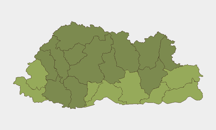
Samtse, Sarpang, and Haa districts rank as highest-risk sub-national zones (scores 58, 55, and 52 respectively), likely reflecting cross-border proximity, terrain challenges, and logistical constraints rather than active security incidents. The eastern and southern border districts—including Pemagatshel, Samdrup Jongkhar, and Tsirang—show elevated risk profiles consistent with geographic remoteness and limited infrastructure. By contrast, central and northern districts (Lhuntse, Gasa, Wangdue Phodrang) register lower risk. These rankings appear driven by structural vulnerability and access limitations rather than by current conflict, crime, or unrest; no recent event data supports active threat escalation in any district.
How GeoBit Would Assist
For ongoing Bhutan operations, security teams would deploy AOI (Area-of-Interest) Monitoring & Early Warning on high-risk districts (Samtse, Sarpang, Haa) to detect any emergence of cross-border activity, civil unrest, or infrastructure disruption. Intel Sweep and multi-language OSINT (social media, local news, regional feeds) would provide continuous low-noise alerting on political instability, protests, or security incidents. Routing & Network Analysis would support contingency planning for personnel or asset movement through remote zones by identifying alternative routes and network vulnerabilities in case of infrastructure failure or localized unrest.
7-Day Outlook
No escalation trajectory is evident. Bhutan's political stability, low crime rate, and geographic isolation support a continued low-threat baseline. Seasonal weather patterns and road conditions remain the primary operational risk drivers for the coming week. Monitoring should remain routine unless regional developments (e.g., cross-border incidents in neighboring India or China-India tensions) generate spillover effects.
Highest-Risk Areas — Ranked
| # | State / Region | Risk |
|---|---|---|
| 1 | Samtse District | 58 |
| 2 | Sarpang District | 55 |
| 3 | Haa District | 52 |
| 4 | Pemagatshel District | 50 |
| 5 | Samdrup Jongkhar District | 48 |
| 6 | Tsirang District | 45 |
| 7 | Zhemgang District | 42 |
| 8 | Trashigang District | 40 |
| 9 | Mongar District | 38 |
| 10 | Gasa District | 35 |
| 11 | Lhuntse District | 32 |
| 12 | Wangdue Phodrang District | 30 |
Sources
Previous Daily Briefs
A new Bhutan brief is written every day — each with its own risk map and downloadable CSV. Here's the last week; use the calendar to go further back.
- August 23, 2026
- August 21, 2026
- August 18, 2026
- August 16, 2026
- August 14, 2026
- August 12, 2026
- August 10, 2026
📅 Browse every day by calendar →
Highlighted days have a brief. Tap a day for that day's map & analysis, or “csv” for that day's dataset ($5).
Atlas — our AI intelligence desk — emails them this snapshot personally. Nothing else, no list.