Situation Summary
Burkina Faso remains under sustained militant pressure across its northern and eastern territories, with composite threat ranking at #29 globally (79/100). The past 48 hours have seen confirmed large-scale military operations against jihadist positions in the Sahel region, alongside lethal attacks on security forces in at least two provinces, indicating that insurgent groups retain the capability to strike both military and civilian targets despite ongoing counterterrorism efforts. The operational tempo and geographic spread of incidents—from Solhan in the north to Dédougou in the west—signal continued fragmentation and difficulty in consolidating territorial control.
Key Developments
- Djibo–Tougan Corridor, Soum & Boucle du Mouhoun (8–9 July 2026): Burkinabè armed forces conducted large-scale counterterrorism operations claiming neutralization of over 400 militants and seizure of 250+ motorcycles, 353 weapons, and communications equipment. Road travel along this axis faces elevated ambush and IED risk in the immediate aftermath.
- Solhan, Yagha Province, Sahel Region (weekend 5–6 July, reported 8–9 July): Armed militants mounted a night-time attack on local security and volunteer forces, resulting in multiple fatalities and confirming continued insurgent capability in the northeast.
- Military Base Near Dédougou, Boucle du Mouhoun (weekend 5–6 July, reported 8–9 July): Militants attacked a military installation, contributing to at least 22 confirmed deaths of soldiers and civilian volunteer defense forces (VDPs) across the two incidents.
- Multi-Zone Militant Pressure, Northern & Eastern Rural Areas (early July, consolidated reporting 8–9 July): Military-aligned sources report coordinated insurgent activity across multiple contested zones, prompting intensified patrols and search operations by government and volunteer forces.
- Checkpoint Proliferation & Movement Restrictions (7–10 July, ongoing): Following recent clashes, expect reinforced security checkpoints and possible short-notice movement restrictions on rural routes in the north and east.
Highest-Risk Areas
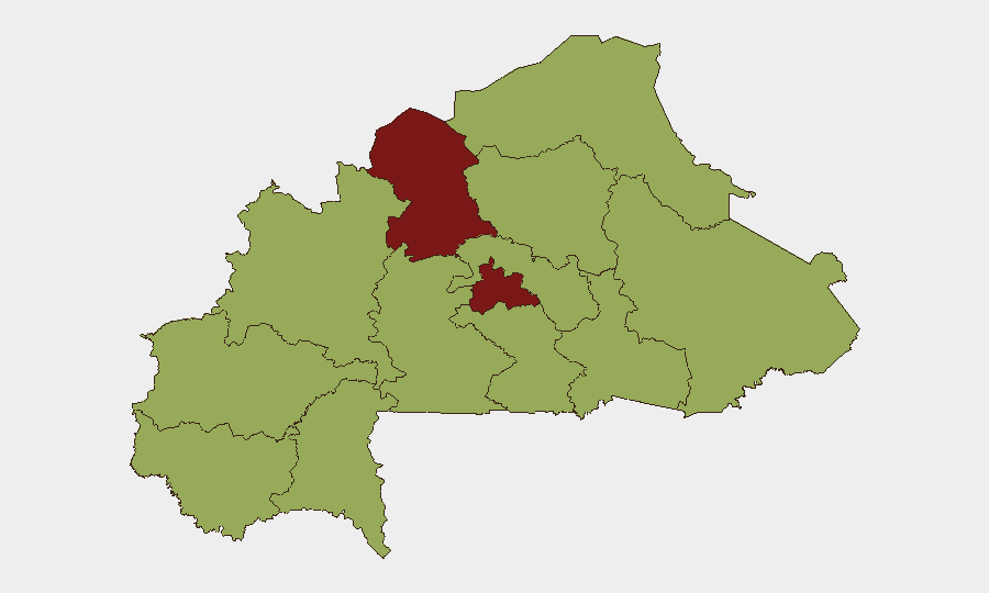
North and Centre regions remain the conflict epicenter, each with a composite risk score of 85.6, driven by ongoing jihadist operations and military counter-campaigns in Soum, Yagha, and Oudalan provinces. Nine additional regions—including Upper-Basins, Boucle du Mouhoun, Central-West, Sahel, and East—rank at 55.6, reflecting secondary but sustained militant activity, road ambush risk, and operational spillover from the primary conflict zones. The Djibo–Tougan axis and areas surrounding Dédougou and Solhan should be treated as immediate high-threat corridors for the next operational cycle.
How GeoBit Would Assist
Security and risk teams should deploy AOI Monitoring & Early Warning to track developments in Soum, Yagha, and Boucle du Mouhoun provinces in real time, with Intel Sweep and multi-language OSINT (X/Twitter, Telegram, regional news feeds) to capture tactical updates on militant activity and military operations before they affect personnel or asset movement. Routing & Network Analysis can identify alternative routes avoiding the Djibo–Tougan corridor and other high-risk axes, while Conflict & Military force-structure tracking and GIS & Spatial Analysis enable mapping of recent operation sites and checkpoint density to inform duty-of-care decisions.
7-Day Outlook
The intensity of military operations and militant counterattacks suggests a sustained cycle of offensive and defensive operations through mid-July, with limited window for stabilization. Road movements in the Sahel and northern regions should be treated as high-risk through at least 15 July; checkpoint activity and short-notice curfews are probable. Organizations should maintain heightened alert status and consider deferring non-essential travel to affected provinces.
Highest-Risk Areas — Ranked
| # | State / Region | Risk |
|---|---|---|
| 1 | North | 85.6 |
| 2 | Centre | 85.6 |
| 3 | Upper-Basins | 55.6 |
| 4 | Boucle du Mouhoun | 55.6 |
| 5 | Central-West | 55.6 |
| 6 | Central-South | 55.6 |
| 7 | Central-East | 55.6 |
| 8 | Waterfalls | 55.6 |
| 9 | Southwest | 55.6 |
| 10 | Sahel | 55.6 |
| 11 | Central-North | 55.6 |
| 12 | East | 55.6 |
Sources
Previous Daily Briefs
A new Burkina Faso brief is written every day — each with its own risk map and downloadable CSV. Here's the last week; use the calendar to go further back.
📅 Browse every day by calendar →
Highlighted days have a brief. Tap a day for that day's map & analysis, or “csv” for that day's dataset ($5).
Atlas — our AI intelligence desk — emails them this snapshot personally. Nothing else, no list.