Situation Summary
Iceland remains a low-threat environment (global rank #63, composite score 28) with no tracked active security events as of 2026-08-09. Recent incident activity has been concentrated in Reykjavík and the Capital Region, dominated by minor public-order incidents and a high-profile maritime enforcement operation. The security trajectory is stable; no indicators of escalating violence, organized crime activity, or systemic instability are present.
Key Developments
- Reykjavík Harbour, 2026-08-05 to 2026-08-06 – Icelandic authorities expelled and issued re-entry bans for 21 crew members of the anti-whaling vessel *Bandero* following Coast Guard detention related to alleged interference with lawful whaling operations. The crew were subsequently permitted to depart the vessel.
- Downtown Reykjavík, 2026-08-04 (~05:00) – Police responded to a group altercation in central Reykjavík, detaining two individuals. No injuries or property damage were reported; incident contained with no secondary escalation.
- Breiðholt, Reykjavík, 2026-08-03 to 2026-08-04 – One individual was held in custody on suspicion of bodily assault (*líkamsárás*) in the Breiðholt police district. Limited detail available; no indication of organized involvement.
- Suðursveit, Southern Region, 2026-08-03 – A bus carrying ten passengers was involved in a traffic accident resulting in six injuries. The Coast Guard helicopter was dispatched for medical evacuation; incident appears weather or road-condition related rather than security-driven.
- Strandir Area, 2026-08-07 to 2026-08-08 – The Icelandic Meteorological Office issued warnings for heavy rainfall and elevated landslide/rockfall risk affecting road networks and transport infrastructure in northwestern coastal areas.
- Seismic Activity, last 48 hours (through 2026-08-08 09:20 GMT) – The Meteorological Office recorded only minor seismic activity; largest recorded magnitude 2.1 near Goðabunga. No major quake alert or secondary hazard concern.
Highest-Risk Areas
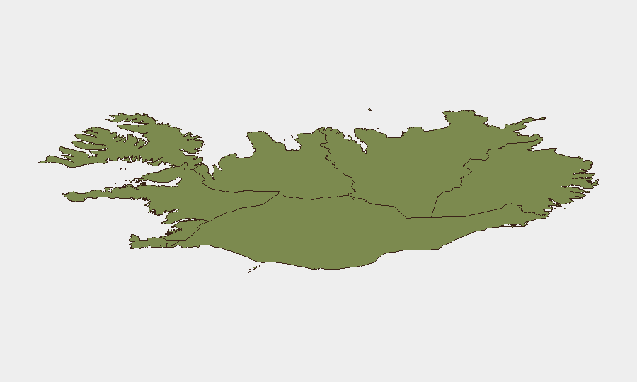
The Capital Region (risk score 24) dominates Iceland's threat landscape, driven by Reykjavík's concentration of population, tourism, and public-order incidents. Recent altercations and assault cases have all occurred in Reykjavík districts, reflecting typical metropolitan-area baseline crime rather than organized or targeted activity. The Southern Peninsula and Southern Region (scores 12 and 11 respectively) present secondary risk, primarily from terrain and weather hazards (landslides, road accidents) rather than deliberate threats. Eastern, Western, and northern regions carry minimal risk scores (6–10), with limited incident reporting and sparse population density.
How GeoBit Would Assist
Security teams with personnel or assets in Iceland would employ AOI Monitoring & Early Warning to track Reykjavík and capital-region venues (accommodation, transport hubs, event spaces) for emerging crowd incidents or protest activity. Multi-language OSINT and X/Twitter analysis would provide early detection of organized activism (e.g., further anti-whaling or environmental demonstrations) before escalation. Environmental & Health intelligence combined with GIS & Spatial Analysis would flag weather, seismic, and landslide risk to support duty-of-care route planning and personnel safety in the Southern Peninsula and coastal regions.
7-Day Outlook
No significant security deterioration is forecast over the next seven days. Reykjavík-area public-order incidents appear sporadic and low-level; continued routine police response is expected. Weather-related transport and infrastructure risk in the Strandir and southern coastal zones will likely persist through mid-August, making alternative-route planning and real-time travel monitoring prudent for operational teams.
Highest-Risk Areas — Ranked
| # | State / Region | Risk |
|---|---|---|
| 1 | Capital Region | 24 |
| 2 | Southern Peninsula | 12 |
| 3 | Southern Region | 11 |
| 4 | Eastern Region | 10 |
| 5 | Western Region | 9 |
| 6 | Westfjords Region | 8 |
| 7 | Northwestern Region | 7 |
| 8 | Northeastern Region | 6 |
Sources
Previous Daily Briefs
A new Iceland brief is written every day — each with its own risk map and downloadable CSV. Here's the last week; use the calendar to go further back.
📅 Browse every day by calendar →
Highlighted days have a brief. Tap a day for that day's map & analysis, or “csv” for that day's dataset ($5).
Atlas — our AI intelligence desk — emails them this snapshot personally. Nothing else, no list.