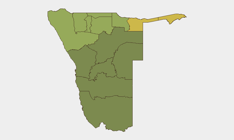
Situation Summary
Namibia remains a low-threat environment globally (rank #109, composite score 14) with no tracked security events in the current reporting window. The country's overall stability masks significant regional variation, with northern border regions—particularly Zambezi, Kavango East, and Kavango West—exhibiting substantially elevated risk profiles. No acute civil unrest, conflict escalation, or infrastructure disruption has been reported in the last 24–48 hours.
Key Developments
No discrete security, conflict, crime, or civil-unrest incidents were verified in Namibia during the last 24–48 hours. Recent web research surfaced routine governance and infrastructure announcements (CRAN–NORED MoO on 25 Aug; railway operational commentary on 24 Aug; land-policy reporting on 24 Aug) but no active threat events meeting the security incident threshold. A reported aviation fuel quality issue at Hosea Kutako International Airport was dated 21 August and falls outside the current 24–48-hour window; routine monitoring of port and airport operations is recommended to confirm current supply status.
Highest-Risk Areas
Zambezi Region (risk 68) dominates the sub-national threat landscape, followed by Kavango East (62) and Kavango West (58). These three northern border zones collectively account for the country's elevated composite risk and warrant priority monitoring by teams with personnel or assets in those areas. The risk profile reflects cross-border dynamics, remote infrastructure, and limited state presence in dispersed settlements. By contrast, central and southern regions—including Windhoek's Khomas district and the coastal Erongo Region—present materially lower risk profiles and support routine business-as-usual operations for most corporate security postures.
How GeoBit Would Assist
Corporate security teams should deploy Area-of-Interest (AOI) Monitoring & Early Warning on Zambezi and Kavango regions to capture emerging civil unrest, movement anomalies, or infrastructure disruption with alert triggers; this capability provides persistent watch without manual daily review. OSINT Fusion & Corroboration across Namibian media, social platforms (X, Telegram), and radio signals would triangulate any localized incidents before they escalate or affect staff safety or supply chains. For duty-of-care teams, Routing & Network Analysis can identify real-time alternative transport and supply-chain pathways if northern corridors face disruption, and Conflict & Military tracking will flag any cross-border movement or regional escalation from Angola or Zambia that could spill into Namibia's northern provinces.
7-Day Outlook
No imminent security deterioration is anticipated over the next seven days. Namibia's political calendar and regional context remain stable; however, the persistent elevated risk in Zambezi and Kavango regions warrants continuous low-level monitoring, particularly around cross-border movement and informal-settlement dynamics. Teams should maintain standard duty-of-care protocols and confirm local liaison relationships in high-risk zones to enable rapid situational awareness if conditions change.
Highest-Risk Areas — Ranked
| # | State / Region | Risk |
|---|---|---|
| 1 | Zambezi | 68 |
| 2 | Kavango East | 62 |
| 3 | Kavango West | 58 |
| 4 | Kunene Region | 52 |
| 5 | Oshikoto | 48 |
| 6 | Ohangwena | 45 |
| 7 | Omusati | 42 |
| 8 | Oshana | 40 |
| 9 | Otjozondjupa | 35 |
| 10 | Erongo Region | 32 |
| 11 | Hardap | 28 |
| 12 | Omaheke | 25 |
Sources
Previous Daily Briefs
A new Namibia brief is written every day — each with its own risk map and downloadable CSV. Here's the last week; use the calendar to go further back.
- August 25, 2026
- August 23, 2026
- August 21, 2026
- August 19, 2026
- August 17, 2026
- August 15, 2026
- August 13, 2026
📅 Browse every day by calendar →
Highlighted days have a brief. Tap a day for that day's map & analysis, or “csv” for that day's dataset ($5).
Atlas — our AI intelligence desk — emails them this snapshot personally. Nothing else, no list.