Situation Summary
Norway remains a low-threat environment (global rank #50, composite threat score 35) with civil unrest as the primary driver. However, a convergence of violent incidents, infrastructure disruption, and security breaches has elevated operational risk in the capital region and southeastern counties over the past week. The national air traffic controller strike (commencing 21 August) compounds travel and logistics risk across major airports.
Key Developments
- Air Traffic Controller Strike (21–22 August). National strike action began after mediation talks failed on 19 August. Avinor reports significant restrictions and periodic airspace closures affecting Oslo Airport Gardermoen, Bergen Flesland, and Western Norway airports on 22 August, with delays and cancellations expected to persist. Travel contingency and freight rerouting are now necessary.
- Ongoing violent incidents across multiple regions (18 August, recent). Police responded to stabbings in Sunnmøre (Ulsteinvik, Ørsta, Volda) involving multiple arrests and hospital admissions. A separate stabbing incident on 18 August in the Bergen area resulted in a man in his 20s being arrested and a victim hospitalized. These incidents reflect elevated interpersonal violence, with no indication of organized or ideological drivers.
- Hostage-taking and assault at IT company (14 August, recent context). An armed man held three employees captive at an IT-company office, restraining victims with tape and inflicting violence. This incident remains under investigation and indicates potential workplace security and personnel vetting gaps in the regional corporate sector.
- Unauthorized drone activity over restricted military facility (15 August). Two foreign nationals were arrested after the Norwegian Armed Forces detected a drone operating over Kolsås camp in Bærum (Akershus), a restricted defense installation. Motivation remains unclear; counterintelligence and border-security response ongoing.
- Fatal arrest incident (18 August). Police arrested a man in his 50s on suspicion of killing an 80-year-old. Officers deployed an electroshock device during the arrest after determining the suspect was armed. Scene management and tactical response were swift; no additional civilian casualties reported.
- Industrial explosion with serious injury (18 August, Lillesand). Emergency services responded to an explosion at a private address, with a male in his 40s sustaining serious burns. Cause under investigation; no broader infrastructure threat indicated at present.
Highest-Risk Areas
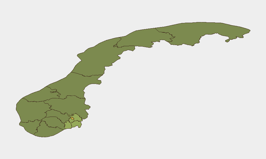
Oslo (risk 68) and Akershus (risk 52) dominate the sub-national ranking, driven primarily by violent crime clustering and the Kolsås military-facility breach. Southeastern counties—Østfold (48), Vestfold (42), and Rogaland (38)—show elevated risk correlating with recent violent incidents and regional socioeconomic patterns. Northern and western regions (Møre og Romsdal, Innlandet, Vestland) remain materially lower-risk, though the strike action has created localized travel friction at Western airports.
How GeoBit Would Assist
Security teams should deploy AOI Monitoring & Early Warning on high-risk municipalities (Oslo, Akershus, Østfold) to detect emerging violence and protest activity in real time. Maritime & Aviation tracking will provide live visibility into airport operational status and cargo routing during the strike. Multi-language OSINT & social-media intelligence (X, Telegram, local news feeds) enable rapid detection of secondary incidents, protest escalation, or organized threats before they reach mainstream reporting.
7-Day Outlook
The air traffic controller strike is expected to persist through at least 24–25 August, with potential for settlement negotiations; alternative routing and ground transport will remain elevated-cost. Violent-incident frequency shows no de-escalation signal; police capacity is absorbed across multiple active investigations. Risk trajectory is stable-to-slightly-elevated; no systemic instability or organized threat indicators detected.
Highest-Risk Areas — Ranked
| # | State / Region | Risk |
|---|---|---|
| 1 | Oslo | 68 |
| 2 | Akershus | 52 |
| 3 | Østfold | 48 |
| 4 | Vestfold | 42 |
| 5 | Rogaland | 38 |
| 6 | Buskerud | 35 |
| 7 | Trøndelag | 32 |
| 8 | Telemark | 28 |
| 9 | Vestland | 27 |
| 10 | Agder | 26 |
| 11 | Møre og Romsdal | 22 |
| 12 | Innlandet | 20 |
Sources
Previous Daily Briefs
A new Norway brief is written every day — each with its own risk map and downloadable CSV. Here's the last week; use the calendar to go further back.
- August 21, 2026
- August 20, 2026
- August 19, 2026
- August 18, 2026
- August 17, 2026
- August 16, 2026
- August 15, 2026
📅 Browse every day by calendar →
Highlighted days have a brief. Tap a day for that day's map & analysis, or “csv” for that day's dataset ($5).
Atlas — our AI intelligence desk — emails them this snapshot personally. Nothing else, no list.