Situation Summary
Tunisia remains a #72 global security concern with a composite threat score of 24, driven primarily by civil unrest rather than active terror incidents. The country faces mounting pressure from overlapping environmental crises (phosphate pollution, forest fires), sustained protests over electricity/water shortages and alleged electoral irregularities, and weather instability across western and central regions. No tracked kinetic security events have occurred in the past 24–48 hours, but infrastructure disruption, border management stress, and localized civil disorder continue as baseline risks.
Key Developments
- Ras Jdir border crossing (southeast Tunisia–Libya border), 16 Aug 2026 – Tunisia closed the Ras Jdir crossing following a security incident linked to migrant movements and bilateral migration tensions. Nature of the incident (armed confrontation vs. threat discovery) remains unclear; expect heightened screening delays and temporary commercial traffic disruption in the Ben Guerdane corridor.
- Ghardimaou–Jendouba–Kef (western governorates), 15–16 Aug 2026 – Strong thunderstorms, heavy rainfall (20–60 mm), hail, and winds exceeding 80 km/h reported forming and spreading. Flash-flooding and wadi overflow risk on mountain intercity routes; secondary risk of localized power cuts.
- Western and central Tunisia (Kasserine, Sidi Bouzid, Siliana, Kairouan), 15–22 Aug forecast window – Meteorological instability forecast through 22 August with near-daily convective storms concentrated over mountainous zones. Cumulative risk of road washouts, landslides on secondary routes, and sustained service interruptions (electricity, telecommunications) in remote areas.
- Gabes (southern coastal, pollution-related protests), ongoing through 14 Aug – Demonstrations against industrial polluters and President Saied's perceived inaction continue; no explicit 24-hour confirmation of new incidents, but localized road blockages and confrontational gatherings remain possible around industrial zones and city center.
Highest-Risk Areas
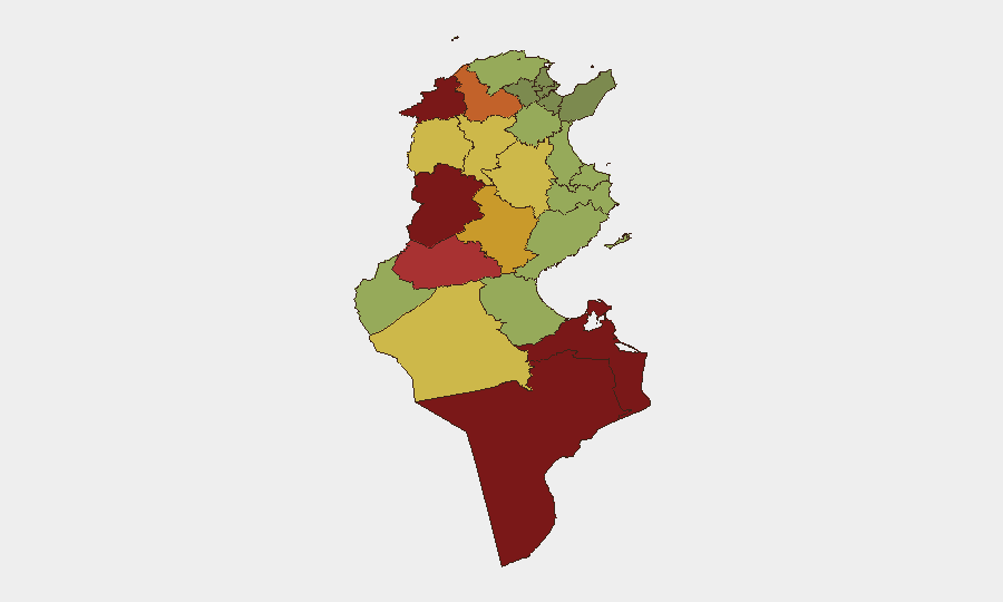
Kasserine, Jendouba, and Tataouine lead sub-national risk rankings (92, 88, and 85 respectively), driven by chronic socioeconomic marginalization, militant infiltration routes from Libya, and overlap with current environmental crises. Kasserine's phosphate belt is a flashpoint for pollution-linked unrest; Jendouba is currently affected by forest fires and severe weather, compounding public anger. Médenine and Gafsa (83 and 78) remain exposed to cross-border instability and resource-scarcity grievances. Together these five governorates concentrate migration pressure, weak state capacity, and protest activity; risk is highest in the mountainous west and remote south.
How GeoBit Would Assist
Corporate security teams should deploy AOI Monitoring & Early Warning on Kasserine, Jendouba, and the Ben Guerdane–Ras Jdir border corridor to detect protest escalation, closure announcements, and secondary delays in real time. Multi-language OSINT and sentiment analysis on social channels and local media will flag emerging grievances around pollution, electoral fraud, and utility cuts before they turn into roadblocks. GIS & Spatial Analysis combined with Environmental & Health intelligence will track weather-driven infrastructure risk and industrial pollution incidents that correlate with protest timing.
7-Day Outlook
Heavy rainfall and thunderstorms will persist through 22 August, creating cumulative flood and landslide risks on western routes and posing secondary threats to power and communications. Civil unrest over pollution and governance is likely to persist but remain localized to industrial zones and urban centers; no national-scale instability is imminent. Border tension at Ras Jdir may extend closure window into early week; monitor for secondary crossing congestion at Ben Guerdane.
Highest-Risk Areas — Ranked
| # | State / Region | Risk |
|---|---|---|
| 1 | Kasserine | 92 |
| 2 | Jendouba | 88 |
| 3 | Tataouine | 85 |
| 4 | Médenine | 83 |
| 5 | Gafsa | 78 |
| 6 | Béja | 75 |
| 7 | Sidi Bouzid | 72 |
| 8 | Al Kaf | 70 |
| 9 | Kébili | 68 |
| 10 | Kairouan | 65 |
| 11 | Siliana | 62 |
| 12 | Tozeur | 58 |
Sources
- al-monitor.com
- ultratunisia.ultrasawt.com
- aa.com.tr
- newarab.com
- ghadnews.net
- entreleslignesentrelesmots.wordpress.com
- almodon.com
- newarab.com
- english.ahram.org.eg
- thehillsjournal.com
- whitehouse.gov
- tuniscope.com
- directinfo.webmanagercenter.com
- jinhaagency1.com
- fr.allafrica.com
- punchng.com
- english.ahram.org.eg
- lapresse.tn
Previous Daily Briefs
A new Tunisia brief is written every day — each with its own risk map and downloadable CSV. Here's the last week; use the calendar to go further back.
- August 15, 2026
- August 13, 2026
- August 11, 2026
- August 9, 2026
- August 7, 2026
- August 5, 2026
- August 4, 2026
📅 Browse every day by calendar →
Highlighted days have a brief. Tap a day for that day's map & analysis, or “csv” for that day's dataset ($5).
Atlas — our AI intelligence desk — emails them this snapshot personally. Nothing else, no list.