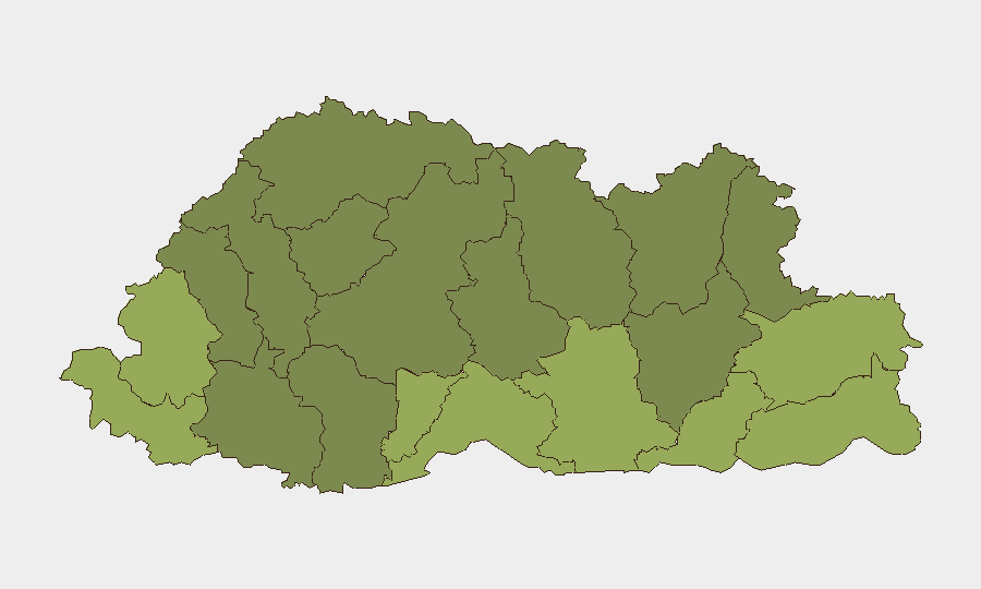
Situation Summary
Bhutan remains a low-threat environment with a composite threat score of 3 and no tracked security events in the current week. The past seven days show no corroborated incidents of armed conflict, insurgent activity, politically motivated violence, large-scale protests, or major crime waves. Key institutional activity has focused on natural-hazard preparedness, public health validation, and emerging attention to cyber-facilitated gender-based violence, reflecting a stable but modernizing governance context.
Key Developments
- Punakha (11 September): Department of Local Governance and Disaster Management, Bhutan Red Cross Society, and Punakha Dzongkhag Administration conducted a major glacial lake outburst flood (GLOF) evacuation drill at Punakha Dzong, explicitly communicated to the public as a preparedness exercise to mitigate climate-driven flood risk in a critical cultural and infrastructure site.
- Wangdue Phodrang (reported 9 September): Round-the-clock monitoring of Himalayan glaciers and associated lakes is ongoing to assess and mitigate GLOF risk to downstream communities; no acute incident reported, but underscores structural environmental hazard management.
- National (reported 14–15 September): UNFPA and Bhutanese NGO RENEW issued a joint call for strengthened institutional response to online gender-based violence, highlighting digital harassment and abuse of women and girls as an emerging priority.
- Thimphu (decision 11 September, reported 12 September): Thimphu Court ordered diversion (restorative, non-custodial handling) for ten children involved in a battery case, indicating isolated youth violence but functioning juvenile-justice and child-protection systems with no indication of wider unrest.
- National (validated 11 September): WHO officially validated Bhutan's elimination of canine-transmitted rabies as a public-health problem, reducing zoonotic-disease risk for residents and travelers.
- Thimphu (reported 9 September): Local reporting identified addressing and wayfinding infrastructure gaps in Thimphu, reflecting administrative modernization needs rather than acute security issues.
Highest-Risk Areas
Samtse, Sarpang, Haa, and Pemagatshel districts in southern and western Bhutan carry the highest composite risk scores (48–58), likely driven by proximity to international borders, terrain complexity, and relative remoteness from central administrative capacity. Samdrup Jongkhar, Tsirang, and Zhemgang (scores 48, 45, 42) continue as secondary-tier risk zones. These rankings reflect structural vulnerabilities—terrain, border access, administrative reach—rather than current active incidents; no events have been recorded in any district in the current week. The concentration of risk in the southern periphery warrants enhanced supply-chain and personnel-duty-of-care planning for operations in those zones.
How GeoBit Would Assist
Organizations with people or assets in Bhutan should use GeoBit's AOI Monitoring & Early Warning capability to establish persistent watches on the highest-risk districts (Samtse, Sarpang, Haa) for any emergence of border incidents, environmental hazards, or civil unrest. Intel Sweep and multi-language OSINT fusion across local news, social media, and official sources will provide early detection of any shifts in the political or security environment. GIS & Spatial Analysis combined with Routing & Network Analysis will support alternative-route planning and supply-chain resilience in the event of localized transport disruption due to flooding or other environmental hazards.
7-Day Outlook
The security trajectory remains stable, with no indicators of escalating conflict or instability. Continued institutional focus on GLOF preparedness, online-safety regulation, and infrastructure modernization will likely dominate the policy agenda. Organizations should maintain routine monitoring posture while prioritizing duty-of-care protocols for personnel in southern districts and environmental-hazard contingency planning.
Highest-Risk Areas — Ranked
| # | State / Region | Risk |
|---|---|---|
| 1 | Samtse District | 58 |
| 2 | Sarpang District | 55 |
| 3 | Haa District | 52 |
| 4 | Pemagatshel District | 50 |
| 5 | Samdrup Jongkhar District | 48 |
| 6 | Tsirang District | 45 |
| 7 | Zhemgang District | 42 |
| 8 | Trashigang District | 40 |
| 9 | Mongar District | 38 |
| 10 | Gasa District | 35 |
| 11 | Lhuntse District | 32 |
| 12 | Wangdue Phodrang District | 30 |
Sources
Previous Weekly Briefs
A new Bhutan brief is written every Monday, covering the week — each with its own risk map and downloadable CSV. Use the calendar to go further back.
- September 8, 2026
- September 1, 2026
- August 29, 2026
- August 26, 2026
- August 23, 2026
- August 21, 2026
- August 18, 2026
📅 Browse past briefs by calendar →
Highlighted days have a brief. Tap a day for that day's map & analysis, or “csv” for that day's dataset ($5).
Atlas — our AI intelligence desk — emails them this snapshot personally. Nothing else, no list.