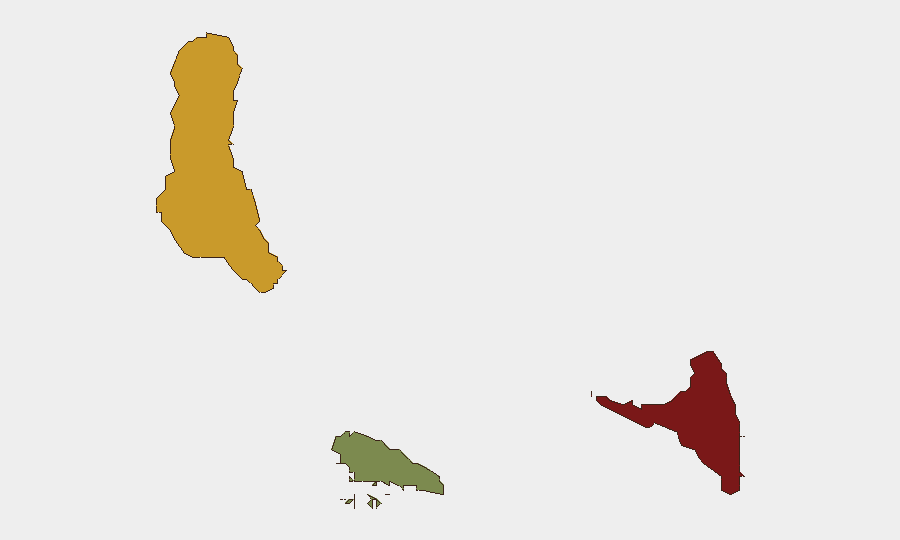
Situation Summary
Comoros remains a low-frequency threat environment at the global level (rank #134, composite score 8), with no confirmed security incidents reported within Comorian territory in the last 24–48 hours. The archipelago's threat profile is driven primarily by maritime exposure (flag-state vessel interdictions linked to transnational crime) and residual civil-unrest pressure tied to economic grievances, particularly on Anjouan. The security picture is stable but fragmented by sub-national variation, with Anjouan bearing disproportionate risk.
Key Developments
No verifiable incidents confirmed in Comoros territory, 15–16 August 2026.
The most recent Comoros-related event on record involves the Ivorian Navy's seizure of the Comoros-flagged vessel *IB Atlantic IV* (flagged Moroni) during a pursuit operation off the Ivorian coast in connection with suspected drug trafficking. The interdiction occurred in early August 2026 (on or before 2 August) and reflects Comoros' exposure to transnational maritime crime rather than a domestic security incident.
Earlier in 2026 (May), Anjouan and Grande Comore experienced civil unrest tied to fuel-price increases, resulting in clashes and casualties; those incidents are outside the current 24–48 hour reporting window but remain contextually relevant to understanding sub-national fragility on Anjouan.
*For intra-day developments or overnight incidents, verification via national media (Al-Watyan, ORTC) and regional Francophone and Arabic sources covering the Indian Ocean region is recommended.*
Highest-Risk Areas
Anjouan dominates the sub-national risk ranking (score 88), driven by a history of secessionist tension, weak state capacity, and economic grievance—particularly fuel scarcity and inflation. Grande Comore (score 72) follows, encompassing the capital Moroni and national institutions; it concentrates population, commerce, and maritime chokepoint activity, amplifying exposure to crime and civil disorder. Moheli (score 35) remains significantly lower-risk. Risk on Anjouan and Grande Comore is structural rather than acute but warrants continuous monitoring, especially during periods of commodity-price volatility or political deadlock.
How GeoBit Would Assist
Security and duty-of-care teams with personnel or assets in Comoros should employ AOI Monitoring & Early Warning to establish persistent watch zones covering Anjouan (Mutsamudu), Grande Comore (Moroni), and key maritime chokepoints; automated alerting will flag civil unrest, crime, or infrastructure disruption in real time. Multi-language OSINT fusion (national broadcast, Francophone press, social-media feeds on X and Telegram) will capture street-level incidents and official statements often missed by English-language global feeds. Maritime tracking (vessel movements, flag-state interdictions, port activity) will provide early signal of transnational crime or sanctions-evasion activity affecting Comoros-flagged assets or port facilities.
7-Day Outlook
No acute security deterioration is forecast for the next seven days. Comoros' risk trajectory remains gradual and driven by economic conditions (commodity prices, currency pressure) rather than political instability or armed conflict. Continued monitoring of Anjouan's political dynamics and fuel availability is warranted; seasonal maritime activity and regional trafficking patterns will sustain low-level flag-state and port-authority interdiction risk.
Highest-Risk Areas — Ranked
| # | State / Region | Risk |
|---|---|---|
| 1 | Anjouan | 88 |
| 2 | Grande Comore | 72 |
| 3 | Moheli | 35 |
Sources
Previous Daily Briefs
A new Comoros brief is written every day — each with its own risk map and downloadable CSV. Here's the last week; use the calendar to go further back.
- August 14, 2026
- August 12, 2026
- August 10, 2026
- August 8, 2026
- August 6, 2026
- August 5, 2026
- August 4, 2026
📅 Browse every day by calendar →
Highlighted days have a brief. Tap a day for that day's map & analysis, or “csv” for that day's dataset ($5).
Atlas — our AI intelligence desk — emails them this snapshot personally. Nothing else, no list.