Situation Summary
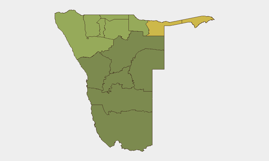
Namibia maintains a low composite threat ranking (#110 globally) with no tracked security events in the current analytical window. However, sub-national risk concentration in the northern and northeastern regions—particularly Zambezi, Kavango East, and Kavango West—reflects persistent human-wildlife conflict, cross-border movement pressures, and localized civil grievance dynamics. A protest incident in Kavango East on 29 August related to crocodile-attack compensation signals emerging community tension around park management and government accountability. Overall trajectory remains stable with contained, geographically isolated risk clusters rather than systemic national instability.
Key Developments
- Mukwe Constituency, Kavango East Region (29 August 2026): Survivors and relatives of crocodile-attack victims initiated a sit-in protest outside Mahango Game Park, demanding formal compensation from Namibia's Ministry of Environment and Tourism. The All People's Party publicly endorsed the action, calling for transparent government response and establishment of a structured compensation mechanism—indicating potential for escalation if grievances remain unaddressed.
- No additional Namibia-specific security, crime, infrastructure, or civil-unrest incidents meeting 24–48-hour recency criteria were confirmed in available sources. Web research and OSINT channels did not return time-stamped reports of other significant developments in the reporting window.
Highest-Risk Areas
Zambezi Region (risk 68) and the two Kavango regions (East 62, West 58) collectively account for the majority of assessed sub-national risk, driven by human-wildlife conflict (particularly predator attacks and park-adjacent communities), seasonal cross-border movement tied to regional migration patterns, and limited state service capacity in remote constituencies. Kunene Region (52) and Oshikoto (48) follow, reflecting ongoing border dynamics and wildlife management pressures. Southern and western regions (Hardap, Omaheke, Erongo) present substantially lower risk profiles. Corporate operations in the north should prioritize monitoring of park-adjacent infrastructure, community relations, and transport corridors; Windhoek and coastal areas remain comparatively secure.
How GeoBit Would Assist
Security teams would deploy AOI (Area-of-Interest) Monitoring & Early Warning on Mukwe constituency, Mahango Game Park, and northern border zones to detect escalation in protest activity, wildlife-conflict incidents, or government response operations before they impact personnel or supply chains. OSINT fusion—combining verified X/Twitter feeds from Namibian journalists, local councillors, NAMPOL statements, and Ministry of Environment communications—would provide real-time corroboration and timeline clarity on civil grievances and official actions. GIS & Spatial Analysis linked to sub-national risk scores enables security teams to refine duty-of-care protocols and alternative routing around Zambezi and Kavango regions where human-wildlife and community-tension risks cluster most densely.
7-Day Outlook
The Mukwe protest is unlikely to escalate to nationwide civil unrest but may sustain local tension around park management and compensation negotiations through early September. Government response (formal engagement with protesters, announcement of compensation framework, or containment measures) will be the critical variable determining whether grievance remains localized or broadens. No indicators suggest imminent systemic instability; routine monitoring of northern regions and government statements remains appropriate for corporate duty-of-care teams.
Highest-Risk Areas — Ranked
| # | State / Region | Risk |
|---|---|---|
| 1 | Zambezi | 68 |
| 2 | Kavango East | 62 |
| 3 | Kavango West | 58 |
| 4 | Kunene Region | 52 |
| 5 | Oshikoto | 48 |
| 6 | Ohangwena | 45 |
| 7 | Omusati | 42 |
| 8 | Oshana | 40 |
| 9 | Otjozondjupa | 35 |
| 10 | Erongo Region | 32 |
| 11 | Hardap | 28 |
| 12 | Omaheke | 25 |
Sources
Previous Daily Briefs
A new Namibia brief is written every day — each with its own risk map and downloadable CSV. Here's the last week; use the calendar to go further back.
- August 28, 2026
- August 25, 2026
- August 23, 2026
- August 21, 2026
- August 19, 2026
- August 17, 2026
- August 15, 2026
📅 Browse every day by calendar →
Highlighted days have a brief. Tap a day for that day's map & analysis, or “csv” for that day's dataset ($5).
Atlas — our AI intelligence desk — emails them this snapshot personally. Nothing else, no list.