Situation Summary
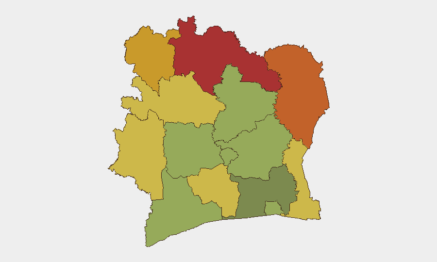
Ivory Coast remains a composite terrorism and insurgency-driven risk at rank #64 globally, with no discrete security incidents tracked during the past week. The primary threat vector continues to centre on the northern border regions and remote eastern districts, where cross-border militant activity and ungoverned space create persistent instability. The security environment is stable in major urban centres, though administrative and infrastructure disputes in Abidjan reflect underlying governance tensions that may complicate longer-term stability.
Key Developments
- Koumassi-Campement, Abidjan — 22 September: The autonomous District of Abidjan publicly backed District Governor Cissé Ibrahima Bacongo amid controversy over demolitions at the Koumassi-Campement site, signalling possible internal political friction over urban land management.
- Abidjan — 23 September: Government clarification that Cissé Bacongo does not sit on the Council of Ministers or the Government Council came as an investigation into the Koumassi-Campement demolitions continued, suggesting potential dispute resolution activity at executive level.
- Plateau lagoon bay, Abidjan — 25 September: The District proceeded with demolishing structures along the Plateau lagoon bay; Plateau municipality indicated it was considering legal action, indicating possible institutional disagreement over urban policy implementation.
Note: No discrete security events (attacks, arrests, militant activity, or major criminal incidents) were confirmed in Ivory Coast during 21–28 September 2026. The three developments above relate to administrative and property disputes in the capital and do not constitute security threats.
Highest-Risk Areas
The northern and north-eastern districts—Savanes (#1, risk 78), Zanzan (#2, 75), and Denguélé (#3, 72)—account for the majority of composite risk and are driven primarily by cross-border insurgency activity, porous frontiers with Mali and Burkina Faso, and limited state capacity. The eastern Comoé and Montagnes districts (ranks 4–5) carry similar drivers. These regions see sporadic militant incursions, arms smuggling, and ungoverned sanctuary space but remain largely absent from recent operational incidents; risk scores reflect persistent structural vulnerabilities rather than active escalation. Abidjan (rank #12, risk 45) is substantially lower-risk and is currently experiencing administrative friction rather than security threats.
How GeoBit Would Assist
Security teams should deploy AOI Monitoring & Early Warning on the Savanes, Zanzan, and Denguélé districts to detect cross-border militant movement, coupled with Intel Sweep and multi-language OSINT (including Telegram and radio SIGINT) to track emerging actor communications and intent. Border & disputed-territory search and GIS & Spatial Analysis can identify key infiltration corridors and ungoverned zones; Network & Actor Analysis will map militant cells and logistics chains. For duty-of-care purposes in Abidjan and other lower-risk urban centres, Routing & Network Analysis enables real-time alternative route planning to avoid administrative hotspots or potential civil friction.
7-Day Outlook
No imminent security escalation is anticipated; the administrative disputes in Abidjan are unlikely to generate security risks to corporate personnel. Northern district risk remains chronic but not acute. Continued monitoring of cross-border activity and militant communications is warranted as standard practice through Q4 2026.
Highest-Risk Areas — Ranked
| # | State / Region | Risk |
|---|---|---|
| 1 | Savanes District | 78 |
| 2 | Zanzan District | 75 |
| 3 | Denguélé District | 72 |
| 4 | Comoé District | 70 |
| 5 | Montagnes District | 68 |
| 6 | Woroba District | 65 |
| 7 | Gôh-Djiboua District | 60 |
| 8 | Sassandra-Marahoué District | 58 |
| 9 | Vallée du Bandama District | 55 |
| 10 | Bas-Sassandra District | 52 |
| 11 | Lacs District | 48 |
| 12 | Abidjan | 45 |
Sources
Previous Weekly Briefs
A new Ivory Coast brief is written every Monday, covering the week — each with its own risk map and downloadable CSV. Use the calendar to go further back.
- September 21, 2026
- September 14, 2026
- September 7, 2026
- September 2, 2026
- September 1, 2026
- August 31, 2026
- August 30, 2026
📅 Browse past briefs by calendar →
Highlighted days have a brief. Tap a day for that day's map & analysis, or “csv” for that day's dataset ($5).
Atlas — our AI intelligence desk — emails them this snapshot personally. Nothing else, no list.