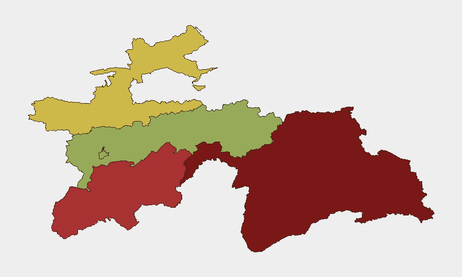
Situation Summary
Tajikistan remains a low-frequency event environment (composite threat score 14; #122 globally), with no confirmed discrete security incidents recorded in the current 7-day window. The country's underlying risk profile is heavily concentrated in its border regions, particularly the mountainous Gorno-Badakhshan Autonomous Region and Khatlon Region, where terrain, transnational smuggling networks, and proximity to instability in Afghanistan create persistent structural vulnerabilities. Dushanbe and urban centers maintain substantially lower operational risk. The threat landscape is defined by chronic rather than acute drivers.
Key Developments
- Tajikistan–Afghanistan border, Gorno-Badakhshan Autonomous Region — 2026-09-08 to 2026-09-09 — Travel-risk advisories noted persistent hazards including unexploded ordnance and landmines in border areas; no new detonation or casualty event was independently confirmed, but the advisory underscores ongoing mine contamination risk in GBAO.
- Tajikistan (nationwide) — 2026-09-10 — A magnitude 4.6 earthquake was reported by social sources citing the National Center for Seismology; secondary confirmation from independent sources was not obtained in the available intelligence set, so treat this as unconfirmed pending corroboration.
- Tajikistan–Afghanistan border — 2026-09-09 — Russian border officials made public statements reaffirming priority focus on Tajikistan's southern frontier, citing counterterrorism and stability concerns related to spillover risks from Afghanistan; this reflects ongoing diplomatic and operational emphasis rather than a discrete new incident.
Highest-Risk Areas
Gorno-Badakhshan Autonomous Region (risk score 92) and Khatlon Region (risk score 78) jointly account for the majority of Tajikistan's residual security risk. Both are defined by remoteness, weak state presence, active cross-border trafficking networks, and proximity to ungoverned or contested Afghan territory. Gorno-Badakhshan's extreme topography and historical conflict legacy—combined with documented mine contamination and limited transport infrastructure—make it the single highest-risk subnational zone. Khatlon, while lower-scored, faces similar transnational smuggling and instability spillover vectors. By contrast, Dushanbe (risk 42) and the capital-proximate Districts of Republican Subordination remain substantially more stable and monitored. Corporate personnel and supply chains should treat southern and eastern border zones as requiring heightened duty-of-care protocols.
How GeoBit Would Assist
Teams with personnel or assets in Tajikistan should employ AOI Monitoring & Early Warning on high-risk regions (particularly Gorno-Badakhshan and the Afghanistan border) to receive alerts on emergent incidents; GIS & Spatial Analysis to model safe routing and identify terrain-constrained travel corridors; and Intel Sweep combined with multi-language OSINT (Telegram, X, local media) to detect early signals of border instability, trafficking escalation, or cross-border armed activity before they reach mainstream international coverage. Satellite imagery and Conflict & Military tracking would support situational awareness of any military deployments or force-posture shifts along the southern frontier.
7-Day Outlook
No imminent escalation is signaled by current data; Tajikistan's threat trajectory remains stable at low-to-moderate baseline. Continued monitoring of the Afghanistan border for spillover risk and seasonal factors (autumn weather may affect accessibility to high-altitude GBAO) should remain routine components of risk management. Any credible seismic activity should be cross-checked with regional geological agencies for impact on infrastructure and population movement.
Highest-Risk Areas — Ranked
| # | State / Region | Risk |
|---|---|---|
| 1 | Gorno-Badakhshan Autonomous Region | 92 |
| 2 | Khatlon Region | 78 |
| 3 | Sughd Region | 65 |
| 4 | Districts of Republican Subordination | 58 |
| 5 | Dushanbe | 42 |
Sources
Previous Weekly Briefs
A new Tajikistan brief is written every Monday, covering the week — each with its own risk map and downloadable CSV. Use the calendar to go further back.
- September 7, 2026
- September 3, 2026
- September 2, 2026
- September 1, 2026
- August 31, 2026
- August 30, 2026
- August 29, 2026
📅 Browse past briefs by calendar →
Highlighted days have a brief. Tap a day for that day's map & analysis, or “csv” for that day's dataset ($5).
Atlas — our AI intelligence desk — emails them this snapshot personally. Nothing else, no list.