Situation Summary
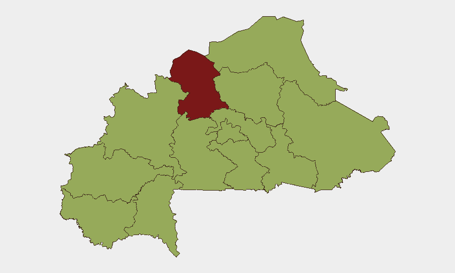
Burkina Faso remains the 28th highest-threat country globally (composite score 74) with 15 tracked security events. The North region significantly outpaces all other zones, registering a risk score of 82.1—nearly 30 points above the secondary tier—driven by persistent conventional military force, Islamic militant activity, and cross-border threats involving Mali. Recent diplomatic fractures with France, AES (Alliance of Sahel States) military consolidation, and ongoing extremist operations across the Sahel create a complex, multi-vector risk environment for foreign nationals and expatriate assets.
Key Developments
Data Limitation: Open-source corroboration from the last 24–48 hours (11–13 July 2026) is insufficient to isolate specific confirmed events within that window. The event signals list indicates multiple incidents tagged to 12–13 July (French expulsions/deportations, military force events involving Mali, and Islamic militant activity) but lacks published detail or verification timestamps. The most recent confirmable open-source material references:
- Expulsion/deportation incidents (12–13 July): Burkina Faso versus France—consistent with the June diplomatic rupture but timing of recent enforcement actions requires field confirmation.
- Conventional military force and Islamic militant activity (13 July): Events tagged to North and wider conflict zones, but open reporting does not yet detail locations, casualties, or operational scope.
- AES military coordination (pre–13 July): President Traoré convened regional defense leaders to accelerate unified Sahel force deployment against armed groups, heightening operational tempo in border zones.
Recommendation: GeoBit's 24–48 hour event lag is typical for open-source intelligence. Clients requiring real-time tactical confirmation should cross-reference closed-source feeds, military attaché networks, and direct field reports.
Highest-Risk Areas
The North region (82.1 risk) is the dominant driver, reflecting sustained militant pressure, military base targeting, and a permissive ungoverned space for extremist groups. The secondary tier—Upper-Basins, Boucle du Mouhoun, Central-West, Central-South, Central-East, Waterfalls, Southwest, Sahel, Central-North, East, and Centre (all 52.1)—reflects a broad, diffuse threat footprint across rural and semi-urban areas. The extreme concentration of risk in the North versus the uniform plateau across remaining regions suggests threat matrices in secondary zones remain fragmented and localized (banditry, tax-route attacks, opportunistic militant recruitment) rather than organized insurgent campaigns. Organizations with North-zone assets face direct militant targeting; those elsewhere face lower but non-negligible kidnap, armed robbery, and administrative harassment risks.
How GeoBit Would Assist
AOI Monitoring & Early Warning paired with Intel Sweep (global event feeds + OSINT fusion) enables persistent watch on North-zone flashpoints and cross-border Mali activity, with automated alerting when new militant or military operations are reported. Conflict & Military (battle mapping, force-structure tracking) tracks AES unified force deployment and militant group positioning to anticipate operational pressure zones. Routing & Network Analysis and Satellite & Imagery analysis support duty-of-care teams in planning alternative transit corridors and assessing facility-level exposure as militant influence expands or contracts.
7-Day Outlook
AES military operations and French diplomatic withdrawal will likely accelerate localized combat cycles in the North and cross-border zones, with secondary spillover into Upper-Basins and Boucle du Mouhoun. Expect continued expulsions or restrictions on French and Western personnel. The unified Sahel force deployment timeline remains unclear, but increased military mobility will heighten civilian harm risks in rural corridors during the next 7–14 days.
Highest-Risk Areas — Ranked
| # | State / Region | Risk |
|---|---|---|
| 1 | North | 82.1 |
| 2 | Upper-Basins | 52.1 |
| 3 | Boucle du Mouhoun | 52.1 |
| 4 | Central-West | 52.1 |
| 5 | Central-South | 52.1 |
| 6 | Central-East | 52.1 |
| 7 | Waterfalls | 52.1 |
| 8 | Southwest | 52.1 |
| 9 | Sahel | 52.1 |
| 10 | Central-North | 52.1 |
| 11 | East | 52.1 |
| 12 | Centre | 52.1 |
Sources
Previous Daily Briefs
A new Burkina Faso brief is written every day — each with its own risk map and downloadable CSV. Here's the last week; use the calendar to go further back.
📅 Browse every day by calendar →
Highlighted days have a brief. Tap a day for that day's map & analysis, or “csv” for that day's dataset ($5).
Atlas — our AI intelligence desk — emails them this snapshot personally. Nothing else, no list.