Situation Summary
Vanuatu remains a low-threat environment globally (rank #156, composite score 7) with no tracked political instability, civil unrest, or crime spikes during the reporting period. However, a major maritime disaster on 11 September—the sinking of inter-island ferry MV Matui with over 40 aboard—has elevated immediate operational risk in the domestic transport sector and triggered a national safety investigation. The incident has exposed regulatory and enforcement gaps in maritime compliance, with preliminary findings pointing to negligence, vessel overloading, and failure to heed weather warnings.
Key Developments
- 11 September 2026, waters between Espiritu Santo and Ambae (northern Vanuatu): Inter-island ferry MV Matui sank during rough seas on the Santo–Ambae route, carrying more than 40 passengers and crew.
- 12–13 September 2026, national level: Vanuatu Prime Minister's Office confirmed at least 1 confirmed fatality, 15 survivors accounted for, and more than 30 people missing; search and rescue operations deployed with French military air support.
- 13 September 2026, Port Vila (central authorities): Government preliminary assessment attributed the sinking to strong winds, failure to heed maritime weather warnings, and possible vessel overloading; formal criminal-negligence and regulatory investigation announced.
- 13–14 September 2026, Santo–Ambae maritime corridor: International search operations (including French military assets) expanded to cover a wide sea area; casualty figures remained fluid during active rescue phase, with conflicting reports citing 2–3 confirmed dead and 18–38 unaccounted for.
- 13–15 September 2026, national policy level: Vanuatu government signalled comprehensive inquiry into maritime safety enforcement, vessel loading practices, and adherence to weather protocols, with prospect of legal consequences and operational tightening for domestic ferry operators.
- 11 September 2026, national: Vanuatu Meteorology and Geohazards Department recorded seismic activity; no associated reports of infrastructure damage or travel disruption retrieved.
Highest-Risk Areas
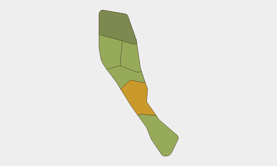
Shefa Province (risk score 72), encompassing the capital Port Vila and southwestern region, drives the highest composite risk; Penama (58) and Sanma (52) follow, with northern and central Vanuatu accounting for the majority of geo-political and operational hazard exposure. The MV Matui sinking occurred in waters north of these rankings (between Santo and Ambae), but the incident has elevated maritime-transport risk across all provinces dependent on inter-island ferry services. Shefa's higher ranking likely reflects Port Vila's urban density, political concentration, and exposure to cyclonic and seismic hazards.
How GeoBit Would Assist
A security team monitoring Vanuatu would employ AOI Monitoring & Early Warning (persistent watch on Santo–Ambae and other high-traffic maritime corridors with alerting for vessel incidents, weather deviations, and SAR operations); Maritime & Aviation tracking (real-time positioning of ferry schedules and weather routing compliance); and Risk & Threat Assessment (scenario modeling for future maritime incidents and regulatory compliance enforcement). Satellite & Imagery analysis can verify vessel condition and port infrastructure, while Intel Sweep and multi-language OSINT provide continuous monitoring of government investigations, operator statements, and emerging policy changes affecting duty-of-care decisions for inter-island travel.
7-Day Outlook
Search operations are expected to continue through mid-week, with casualty figures likely to stabilize by end-of-week. Government investigation and media scrutiny will intensify focus on maritime operator compliance; near-term risk of operational suspensions, route closures, or capacity restrictions on inter-island ferries is elevated. Broader security conditions remain stable, but corporate travel teams should expect delays and increased scrutiny of domestic maritime transport for 10–14 days.
Highest-Risk Areas — Ranked
| # | State / Region | Risk |
|---|---|---|
| 1 | Shefa Province | 72 |
| 2 | Penama | 58 |
| 3 | Sanma | 52 |
| 4 | Malampa | 48 |
| 5 | Tafea | 45 |
| 6 | Torba | 35 |
Sources
Previous Weekly Briefs
A new Vanuatu brief is written every Monday, covering the week — each with its own risk map and downloadable CSV. Use the calendar to go further back.
- September 8, 2026
- September 2, 2026
- August 31, 2026
- August 28, 2026
- August 26, 2026
- August 24, 2026
- August 22, 2026
📅 Browse past briefs by calendar →
Highlighted days have a brief. Tap a day for that day's map & analysis, or “csv” for that day's dataset ($5).
Atlas — our AI intelligence desk — emails them this snapshot personally. Nothing else, no list.