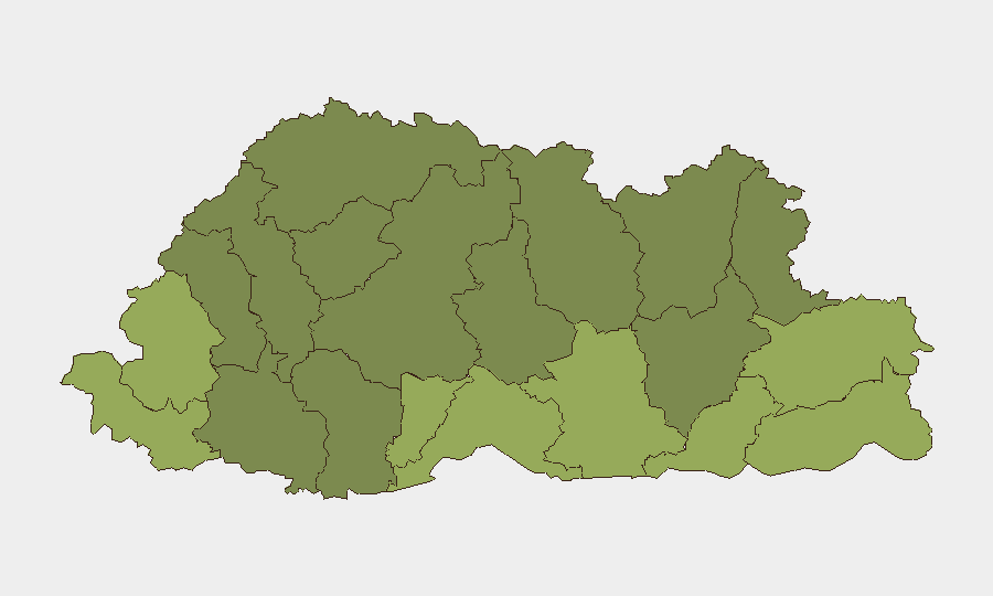
Situation Summary
Bhutan remains among the world's lowest-threat environments, ranked #185 globally with no recorded security incidents during the past seven days. The country's stability trajectory remains positive, with no confirmed reports of crime, civil unrest, armed conflict, or political instability. Border-adjacent districts in the south and east carry elevated composite risk scores, though these reflect structural and geographic factors rather than active incidents.
Key Developments
- Zhemgang District, Chamkarchhu River (October 5, 2026): Adani Power and Druk Green Power Corporation signed a joint development agreement for the 770 MW Chamkharchhu-I hydropower project. Construction is scheduled to begin in H1 2027. The project will operate as a peaking run-of-river facility and represents significant infrastructure investment in a mid-risk district.
No other security-relevant events (involving crime, unrest, conflict, or travel disruption) were confirmed in Bhutan during September 30–October 6, 2026.
Highest-Risk Areas
Samtse, Sarpang, Haa, and Pemagatshel districts drive the composite risk ranking, all concentrated in the southern and eastern border belt. These areas score 50–58, substantially above the national average. Risk drivers in these districts typically correlate with cross-border proximity, terrain accessibility, remote settlement patterns, and limited state presence rather than active threat events. Samtse and Sarpang, bordering India's Assam region, rank highest. Central and northern districts (Thimphu, Wangdue Phodrang, Lhuntse) show significantly lower risk, reflecting urban density, administrative capacity, and distance from international boundaries. Organizations with personnel or assets in the southern border zone should maintain proportionate monitoring protocols; current conditions do not warrant elevated travel restrictions or operations suspension.
How GeoBit Would Assist
Security teams should employ AOI Monitoring & Early Warning to track Samtse and Sarpang districts for emerging civil, cross-border, or resource-competition signals; Intelligence & OSINT (multi-language search, X/Twitter & Telegram feeds, sentiment analysis) to detect early indicators of unrest or criminal activity; and Risk & Threat Assessment to evaluate exposure of personnel near border crossing points or remote infrastructure sites. GIS & Spatial Analysis can support site-specific route planning and safe-area mapping for field operations. Regular entity extraction and network analysis of regional actors—including local authorities, NGOs, and community leaders—provides contextual awareness of local governance capacity.
7-Day Outlook
No escalation vectors are evident. The Chamkharchhu-I hydropower development may generate moderate localized labor migration and supply-chain activity in Zhemgang through 2027, warranting standard project-site security protocols. Bhutan's political and security environment is forecast to remain stable through the near term; seasonal weather patterns (approaching winter monsoon transition) may create routine transportation delays in southern and eastern districts but pose no security threat.
Highest-Risk Areas — Ranked
| # | State / Region | Risk |
|---|---|---|
| 1 | Samtse District | 58 |
| 2 | Sarpang District | 55 |
| 3 | Haa District | 52 |
| 4 | Pemagatshel District | 50 |
| 5 | Samdrup Jongkhar District | 48 |
| 6 | Tsirang District | 45 |
| 7 | Zhemgang District | 42 |
| 8 | Trashigang District | 40 |
| 9 | Mongar District | 38 |
| 10 | Gasa District | 35 |
| 11 | Lhuntse District | 32 |
| 12 | Wangdue Phodrang District | 30 |
Sources
Previous Weekly Briefs
A new Bhutan brief is written every Monday, covering the week — each with its own risk map and downloadable CSV. Use the calendar to go further back.
- September 29, 2026
- September 22, 2026
- September 15, 2026
- September 8, 2026
- September 1, 2026
- August 29, 2026
- August 26, 2026
📅 Browse past briefs by calendar →
Highlighted days have a brief. Tap a day for that day's map & analysis, or “csv” for that day's dataset ($5).
Atlas — our AI intelligence desk — emails them this snapshot personally. Nothing else, no list.