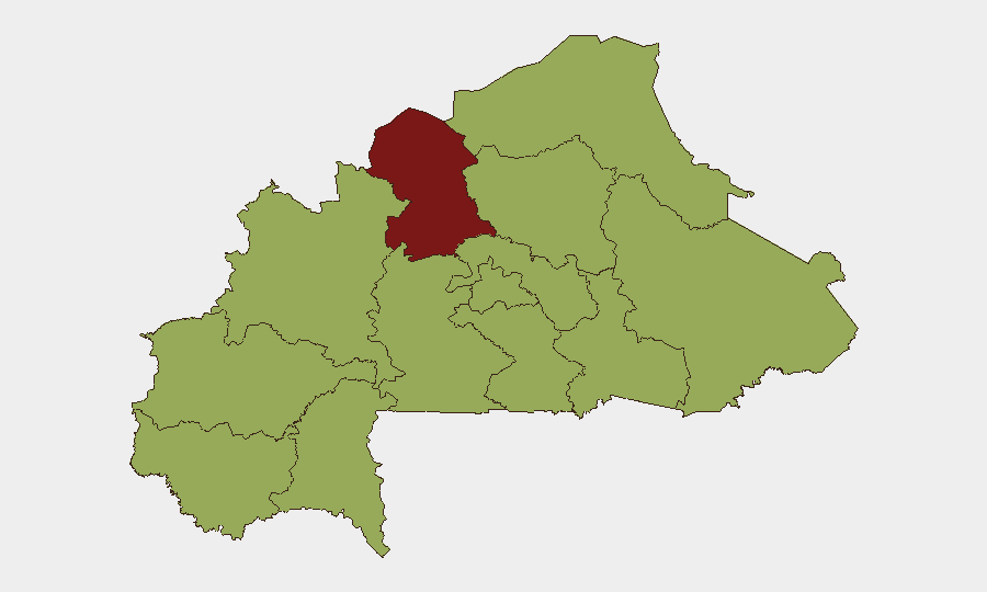
Situation Summary
Burkina Faso remains under elevated structural threat, ranking #28 globally with a composite threat score of 80 across 16 tracked events. The security environment is characterized by persistent armed-group activity in the Sahel and northern regions, though no specific, location-verified kinetic incidents have been documented in the last 24–48 hours (13–15 July 2026), which may reflect reporting gaps rather than operational pause. The country faces sustained pressure from jihadist and community-based armed actors, compounded by recent diplomatic tensions; however, the immediate operational picture shows no confirmed new attacks in the current reporting window.
Key Developments
- No confirmed security or conflict incidents documented in Burkina Faso during 13–15 July 2026. Real-time monitoring feeds report an absence of timestamped, location-verified events in this period, despite the country's generally high baseline threat.
- Elevated threat posture remains structural. The North region (risk score 85.9) and 10 additional regions (each scoring 55.9) reflect persistent armed-group presence and capability, though no new tactical events are currently reported.
- Historical context (early July): Weekend attacks near Di, Dédougou, Kaya, and Seguenega, plus the 6–12 July diplomatic rupture with France, fall outside the current 24–48-hour window but underscore the operational tempo since late June.
- Intelligence signals flagged on 13 July reference conventional military force incidents involving Somalia, Mali vs. Burkina Faso, and Islamic armed actors vs. Burkina Faso; however, these are not corroborated as new confirmed incidents within Burkina Faso proper in the last 48 hours and require verification.
- Reporting lag acknowledged. Absence of documented incidents does not confirm a security lull; communications constraints and delayed OSINT ingestion in remote northern and eastern areas are common.
Highest-Risk Areas
The North region (score 85.9) is the country's principal threat hotspot, driven by entrenched jihadist and splinter armed-group presence and recurrent attacks on civilian and security targets. Nine additional regions—Upper-Basins, Boucle du Mouhoun, Central-West, Central-South, Central-East, Waterfalls, Southwest, Sahel, and Central-North, plus East and Centre—carry equal elevated risk (55.9 each), indicating widespread geographic exposure rather than isolated pockets. This distribution reflects fragmentation of threat actors across the country and limited state capacity to contest multiple fronts simultaneously. Risk is driven by armed-group recruitment, IED activity, and community-security deterioration rather than single high-profile incidents.
How GeoBit Would Assist
Security and duty-of-care teams should leverage AOI Monitoring & Early Warning on personnel locations in the North and Sahel regions to generate real-time alerts on armed-group movement and checkpoints. OSINT Sweep (X/Telegram, regional security feeds, multi-language search) coupled with conflict and military analysis—including force-structure tracking and battle-mapping of armed-group positions—enables teams to distinguish genuine tactical shifts from reporting noise. Routing & Network Analysis is essential for alternative journey planning around high-risk corridors; satellite and imagery analysis provides independent verification of reported incidents and armed-group deployment.
7-Day Outlook
No imminent shift in the baseline threat is anticipated over the next week. Continued low-level armed-group activity and potential community-level tensions are likely, particularly in the North and eastern regions. Teams should maintain heightened awareness protocols and prepare contingency response; verification of any new incident reports through independent OSINT is advised, given communication delays in affected areas.
Highest-Risk Areas — Ranked
| # | State / Region | Risk |
|---|---|---|
| 1 | North | 85.9 |
| 2 | Upper-Basins | 55.9 |
| 3 | Boucle du Mouhoun | 55.9 |
| 4 | Central-West | 55.9 |
| 5 | Central-South | 55.9 |
| 6 | Central-East | 55.9 |
| 7 | Waterfalls | 55.9 |
| 8 | Southwest | 55.9 |
| 9 | Sahel | 55.9 |
| 10 | Central-North | 55.9 |
| 11 | East | 55.9 |
| 12 | Centre | 55.9 |
Sources
Previous Daily Briefs
A new Burkina Faso brief is written every day — each with its own risk map and downloadable CSV. Here's the last week; use the calendar to go further back.
📅 Browse every day by calendar →
Highlighted days have a brief. Tap a day for that day's map & analysis, or “csv” for that day's dataset ($5).
Atlas — our AI intelligence desk — emails them this snapshot personally. Nothing else, no list.