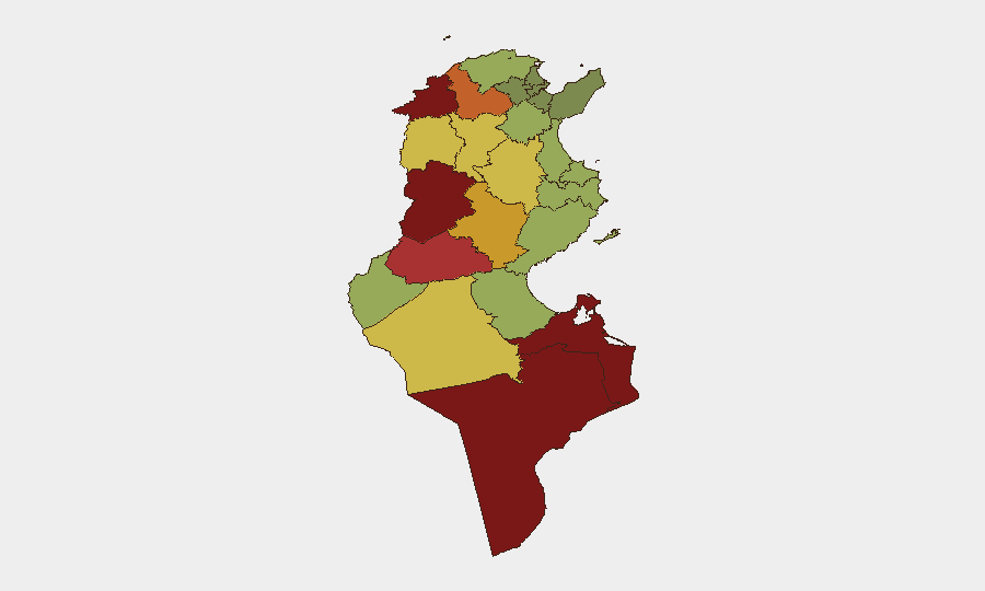
Situation Summary
Tunisia remains at composite threat rank #74 globally with a score of 24, driven primarily by civil unrest. No tracked security incidents have been verified in the last 24–48 hours (26–27 August 2026); however, a nationwide heatwave alert issued on 26 August presents elevated risk of infrastructure strain and heat-related disruptions. The security environment reflects longer-term political tension, socio-economic grievances, and localized volatility in southern and western governorates, with the most recent documented civil unrest occurring in Ben Guerdane (Médenine) on 23–24 August following a migrant boat sinking.
Key Developments
- Nationwide heatwave alert – Tunisia (all regions) – 26 August 2026: Tunisia's meteorological institute placed the country on high alert for an intense heatwave, with public advisories to limit outdoor activity 12:00–16:00 and reduce physical exertion. Risk of power demand spikes, water supply strain, and service disruptions with potential secondary unrest.
- No new major civil unrest or security incidents verified for 26–27 August 2026: Web research, travel advisories, and open sources confirm no documented protests, clashes, or significant crimes within the strict 24–48 hour window; prior unrest (Ben Guerdane riots, Tunis demonstrations) dates to 20–24 August.
- Ben Guerdane tension remains elevated (borderline outside window): Follow-up reports on 25 August indicated ongoing search operations and community tension following 23–24 August riots; local environment remains sensitive but no new incidents confirmed on 26–27 August.
Highest-Risk Areas
Kasserine (risk 92), Jendouba (88), and Tataouine (85) are the three highest-risk governorates, followed by Médenine (83) and Gafsa (78). These western and southern border regions experience chronic socio-economic stress, limited economic opportunity, and historical patterns of protest and sporadic security incidents. Médenine, despite hosting the port city of Ben Guerdane, remains a flashpoint for migration-related unrest and grievances over development disparities. The concentration of risk in the interior and south suggests that corporate operations in coastal and capital-region areas (Tunis, Sfax, Sousse) face materially lower immediate threat, though infrastructure and service disruptions from the heatwave may affect all regions.
How GeoBit Would Assist
AOI Monitoring & Early Warning enables persistent watch on Kasserine, Jendouba, Médenine, and other high-risk governorates with real-time alerting on protest activity, road blockages, or security force movements. Intel Sweep and multi-language OSINT (including X/Twitter, Telegram, and local news feeds) provide rapid identification of emerging unrest, migration incidents, and political messaging before mainstream media coverage. GIS & Spatial Analysis combined with Routing & Network Analysis allow security teams to model alternative transport corridors and supply-chain routes that avoid high-risk zones during periods of elevated tension or infrastructure strain (e.g., during the current heatwave).
7-Day Outlook
The heatwave is forecast to persist through late August, maintaining elevated risk of utilities strain, service disruptions, and associated public frustration. No clear escalation vector is apparent in the next 7 days based on current reporting, though the sensitivity of Ben Guerdane and the broader south to migration-related events means sudden incidents (boat sinkings, detention facility incidents) could trigger rapid protest cycles. Monitoring of police/security deployments and local social media sentiment in Médenine and Gafsa is advised to provide 12–48 hour early warning of renewed unrest.
Highest-Risk Areas — Ranked
| # | State / Region | Risk |
|---|---|---|
| 1 | Kasserine | 92 |
| 2 | Jendouba | 88 |
| 3 | Tataouine | 85 |
| 4 | Médenine | 83 |
| 5 | Gafsa | 78 |
| 6 | Béja | 75 |
| 7 | Sidi Bouzid | 72 |
| 8 | Al Kaf | 70 |
| 9 | Kébili | 68 |
| 10 | Kairouan | 65 |
| 11 | Siliana | 62 |
| 12 | Tozeur | 58 |
Sources
Previous Daily Briefs
A new Tunisia brief is written every day — each with its own risk map and downloadable CSV. Here's the last week; use the calendar to go further back.
- August 25, 2026
- August 23, 2026
- August 21, 2026
- August 19, 2026
- August 17, 2026
- August 15, 2026
- August 13, 2026
📅 Browse every day by calendar →
Highlighted days have a brief. Tap a day for that day's map & analysis, or “csv” for that day's dataset ($5).
Atlas — our AI intelligence desk — emails them this snapshot personally. Nothing else, no list.