Situation Summary
Iceland remains a low-threat environment (global rank #65, composite score 28) with no tracked major security events. Recent incidents cluster in the Capital Region and reflect routine law-enforcement activity, localized property crime, and tourist safety risks rather than organized unrest or political instability. The security trajectory is stable, with no indicators of imminent escalation in violence, infrastructure disruption, or civil disorder.
Key Developments
- Capital Region traffic enforcement surge – Reykjavík, 25–26 August: Police recorded approximately 80 cases during night operations, primarily traffic-related enforcement, with at least one individual held in custody. This reflects routine policing intensity but signals active enforcement presence in the greater Reykjavík area.
- Fatal tourist accident – Stuðlagil canyon, East Iceland, 24–25 August: A foreign tourist in his thirties fell into the Jökla river on 24 August; a large-scale search and rescue operation involving ~100 team members and a Coast Guard helicopter recovered his body late on 24 August at 3–4 meters depth. The incident is being investigated as accidental death and underscores tourism and outdoor-safety risks in Eastern Region attractions.
- Mink farm burglary investigation update – Mosfellsdalur (Capital Region periphery), 26 August: Police report multiple arrests in connection with a break-in and burglary at Dalsbú mink farm. The underlying crime occurred earlier in August; investigation remains open and perpetrators not fully identified. This represents ongoing property-crime investigation activity near the capital.
- Assault with weapons – Central Reykjavík, 23 August: Three individuals were arrested following an assault involving edged weapons and brass knuckles in postal district 105. Incident is part of a cluster of low-level violence and property crime in central Reykjavík over 23–24 August.
- Domestic violence and property crime cluster – Reykjavík and Hafnarfjörður, 23–24 August: Multiple low-level incidents reported in postal districts 105 (central Reykjavík) and 220 (Hafnarfjörður area), including domestic violence and residential burglary with theft. These reflect routine crime patterns in the Capital Region rather than organized activity.
Highest-Risk Areas
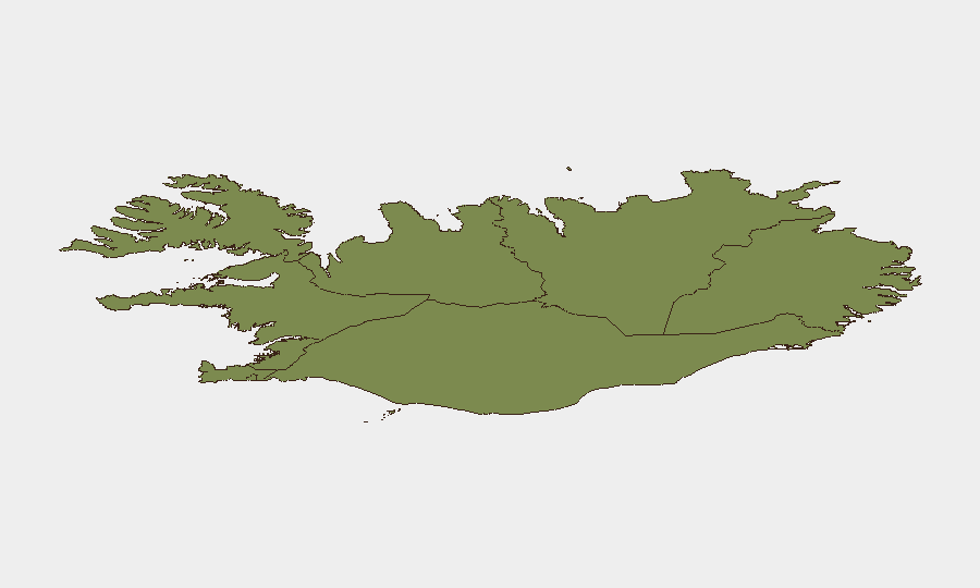
The Capital Region (risk score 24) dominates the sub-national threat profile, driven by incident density in central Reykjavík (postal districts 105, 220) involving assault, domestic violence, and property crime. The Southern Peninsula (risk 12) and Southern Region (risk 11) carry secondary risk. Risk in the Capital Region reflects urban-concentration effects and routine law-enforcement activity rather than systemic instability; peripheral and northern regions show significantly lower incident density and threat scores. Tourism-related accidents (e.g., Stuðlagil canyon) and outdoor-activity risks are geographically dispersed and not captured in violence/crime metrics.
How GeoBit Would Assist
Security teams with personnel or assets in Iceland would use Intel Sweep and multi-language OSINT fusion to monitor emerging unrest, protest activity, or political instability across Icelandic media and social platforms. AOI Monitoring with persistent alerting on the Capital Region and key tourism zones (Southern Peninsula, Stuðlagil) would provide early warning of concentrated crime clusters, infrastructure disruptions, or emergency incidents. Risk & Threat Assessment and GIS spatial analysis would help pinpoint highest-exposure areas and optimize duty-of-care protocols for expatriate or mobile workforces.
7-Day Outlook
No indicators suggest material escalation in violence, crime, or unrest over the next seven days. Routine law-enforcement activity and low-level property crime are expected to continue in urban centers. Tourist safety incidents remain a persistent background risk in outdoor recreation areas, particularly in the East and South; organizations with personnel engaging in hiking or canyon tourism should reinforce safety protocols and emergency response coordination.
Highest-Risk Areas — Ranked
| # | State / Region | Risk |
|---|---|---|
| 1 | Capital Region | 24 |
| 2 | Southern Peninsula | 12 |
| 3 | Southern Region | 11 |
| 4 | Eastern Region | 10 |
| 5 | Western Region | 9 |
| 6 | Westfjords Region | 8 |
| 7 | Northwestern Region | 7 |
| 8 | Northeastern Region | 6 |
Sources
Previous Daily Briefs
A new Iceland brief is written every day — each with its own risk map and downloadable CSV. Here's the last week; use the calendar to go further back.
- August 26, 2026
- August 25, 2026
- August 24, 2026
- August 23, 2026
- August 22, 2026
- August 21, 2026
- August 20, 2026
📅 Browse every day by calendar →
Highlighted days have a brief. Tap a day for that day's map & analysis, or “csv” for that day's dataset ($5).
Atlas — our AI intelligence desk — emails them this snapshot personally. Nothing else, no list.