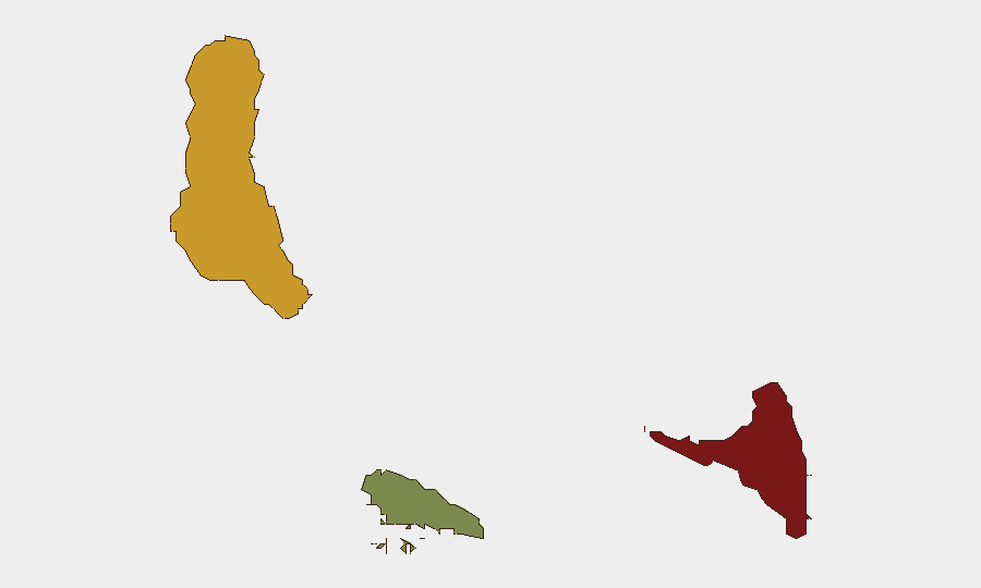
Situation Summary
Comoros remains a low-frequency, moderate-risk environment globally (ranked #155 overall; composite threat score 8). The archipelago continues to experience localized security challenges centered on maritime crime and irregular migration flows, particularly affecting Mohéli. No major escalation or systemic instability has been reported in the past week, and the threat environment remains fragmented and geographically concentrated rather than state-wide.
Key Developments
- Mohéli, 8 October 2026: Prosecutors confirmed that five Comorian men were remanded at Badjo prison on suspicion of migrant smuggling and aiding migrant movement. This followed the interception of more than 200 migrants near or on Mohéli since 9 September.
- Mohéli (including Ouallah/Wallah), early October 2026, reported 8–9 October: Authorities continued investigation into migrant-smuggling networks after two groups of migrants arrived or were abandoned near coastal areas; 73 migrants had been transferred to Moroni on 4 October, while four others escaped during the process.
- Background context (September 2026): Three soldiers stationed in Mohéli and assigned to guard a hydrocarbon storage depot were accused of fuel theft, reflecting broader security control and asset-protection vulnerabilities in the outer islands.
Highest-Risk Areas
Anjouan (risk score 88) and Grande Comore (risk score 72) represent the primary drivers of aggregate archipelago risk, while Mohéli (score 35) remains secondary but operationally significant due to recent migrant-smuggling activity and border/maritime exposure. Anjouan's elevated score reflects historical governance fragility and limited state capacity; Grande Comore, as the seat of national government and largest population center, concentrates political and economic activity. Mohéli's lower but concerning score masks its disproportionate exposure to maritime crime networks and irregular migration flows, which create secondary recruitment, trafficking, and security-force corruption risks.
How GeoBit Would Assist
Teams with personnel or assets in Comoros should employ AOI Monitoring & Early Warning on Anjouan, Grande Comore, and Mohéli's coastal zones to track migrant-smuggling activity, irregular arrivals, and associated law-enforcement responses in near-real time. Network & Actor Analysis applied to remanded smuggling suspects and maritime crime cells would map organizational structure, trafficking routes, and complicity patterns among security and port officials. Maritime & Aviation Tracking linked to GIS & Spatial Analysis enables identification of departure zones, interception hotspots, and transit corridors, informing travel routing and asset-protection decisions for corporate or NGO operations dependent on maritime logistics.
7-Day Outlook
Migrant-smuggling investigations are likely to continue through early-to-mid October, with additional arrests and prosecutions probable as authorities pursue network members and collaborators. No imminent escalation to armed conflict, civil unrest, or major infrastructure disruption is indicated; risk trajectory remains stable but persistent. Monitoring of Anjouan governance stability and Grande Comore political developments should remain routine, while Mohéli maritime activity warrants heightened attention given trafficking volume and security-force involvement.
Highest-Risk Areas — Ranked
| # | State / Region | Risk |
|---|---|---|
| 1 | Anjouan | 88 |
| 2 | Grande Comore | 72 |
| 3 | Moheli | 35 |
Sources
Previous Weekly Briefs
A new Comoros brief is written every Monday, covering the week — each with its own risk map and downloadable CSV. Use the calendar to go further back.
- October 6, 2026
- September 29, 2026
- September 22, 2026
- September 15, 2026
- September 8, 2026
- September 1, 2026
- August 30, 2026
📅 Browse past briefs by calendar →
Highlighted days have a brief. Tap a day for that day's map & analysis, or “csv” for that day's dataset ($5).
Atlas — our AI intelligence desk — emails them this snapshot personally. Nothing else, no list.